
 | |
| Volume 6, Number 4 | July/August 2000 |
I spent five days in June this summer exploring Mount Yeroham and the region around it in the northern Negev of Israel.[1] This excursion was a great success. My desire now is to share as much of my experience with you, my readers and friends, as the medium of writing may permit.
This goal cannot be accomplished in a single issue. In the present article I focus on the foundational issue of how we can be confident Mount Yeroham is the true Mount Sinai. In future issues I hope to report on the excursion itself, including many photographs which were taken while at Yeroham. I am also hoping, before too many months have passed, to make more of this experience available on video, from footage filmed on site.
The total personnel for this excursion consisted of myself, Dr. Gerald E. Aardsma, and my cameraman, Philip Gioga (pronounced Joy-a). Philip is a friend of the family of a number of years and a college student in a communications program.
I have previously proposed that Mount Yeroham is the Biblical Mount Sinai.[2] This proposal is unusual only in the sense that, to the best of my knowledge, nobody has ever proposed this specific mountain before. Many other mountains have been proposed in the past, and proponents of a variety of candidate mountains can be found at present. Bible encyclopedias will typically list several candidates and state that it is impossible to tell today which is the true Mount Sinai.
But the Bible encyclopedias are wrong. They are currently all out of date on this matter. Times have changed.
It was impossible to figure out which was the true Mount Sinai ten years ago. As we will see below, correct chronology is vital to this problem, and ten years ago everyone was using a chronology for the Bible which was wrong—badly wrong.
That all changed with the discovery in 1990 that a thousand years had accidentally been dropped from 1 Kings 6:1.[3] With that discovery many longstanding, murky problems in ancient Bible history suddenly began to clarify. And one of those problems was the identification in the modern world of the mountain upon which Moses once stood and received the Ten Commandments on tablets of stone from the hand of God.
Mount Yeroham is not just another candidate. It is the candidate one finds when one has their Biblical chronology right.
My main objective in visiting Yeroham was not to prove that Mount Yeroham is Mount Sinai. However, having been there has removed all objective grounds for doubting the validity of this identification. There is very much about Yeroham which corroborates its equivalence with Sinai and nothing about it that I have been able to find which falsifies this identification.
I had two main reasons for wanting to visit Mount Yeroham. First was the purely scientific motive of documenting the state of the site today. I wanted to capture as much factual information as possible about the site before its intrinsic nature becomes submerged beneath national and/or commercial interests.
Second was a motive—not far removed from science, by any means—of curiosity. I wanted to enter into the experience of Moses and the Israelites as they camped at the foot of Mount Sinai four and a half thousand years ago. I wanted to know, first hand, what a sunrise was like at Sinai—how it must have felt to the Israelites as they rose to each new day in their tent city at the base of Sinai. I wanted to see what they would have seen: the rocks, the desert vegetation, the insects… I wanted to feel the heat they would have felt. I wanted to handle broken fragments of the pottery vessels they once carried water in, or ate their meals from. I wanted to view the form of Mount Sinai as they would have been familiar with it. I wanted to climb the mountain, as Moses would have climbed the mountain—to feel the physical exertion he would have felt laboring upward under the desert sun. I wanted to step into the bamah that Moses had built on the mountain,[4] and see the view of the Sinai plain far below, as he did. I wanted to ascend to the summit in his footsteps. I wanted to know what kind of rock the Ten Commandments had been written on. I wanted to learn whatever I could of the physical manifestations of God's presence on the mountain—the smoke, the fire, the sound of the trumpet, the thunder. I wanted to exorcize both dusty scholarly speculations and scintillating Hollywood imaginations about Sinai with a hefty dose of the real thing. I wanted to drink in as much of the brute physical reality of Sinai as was possible for any individual, these four and a half thousand years after the Israelites had been there.
I have now fulfilled these aspirations. There is much I want to pass along to you. But before I do, it seems necessary to set forth, as clearly as possible, the objective grounds upon which the identification of Yeroham with Sinai rests.
Science proceeds by logical induction, rather than deduction. This means that proofs of the sort one finds in mathematics are impossible in science. The basic logic of scientific discovery is to: 1. formulate a hypothesis, and then 2. proceed to test the hypothesis. The hypothesis may fail the test. In that case it has been falsified. One then discards it and tries to formulate a better hypothesis. On the other hand the hypothesis may pass the test. In that case it has been corroborated. Note immediately that corroboration is not proof. The hypothesis may fail a different test, showing that it is false after all. But the more different tests a hypothesis passes, the greater its degree of corroboration, and the greater our confidence grows that it is a valid statement about reality.
The hypothesis of interest in the present case is: Mount Yeroham is the Biblical Mount Sinai. A set of seven basic tests plus two site-specific tests of this hypothesis leading to confidence in its validity are summarized below.
Mount Sinai is depicted in the Bible as a mountain. If Mount Yeroham is the Biblical Mount Sinai then Mount Yeroham must be a mountain.
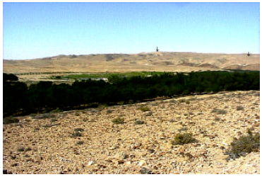
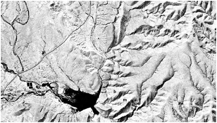
Mount Yeroham is, as its name implies (and as I can now verify from my own first-hand experience), a mountain. It is not a very tall mountain, as far as mountains go. It is a low, sprawling mountain (Figures 1 and 2). Its summit is only 2,156 feet above sea level, and only 580 feet above the wadi bed at its base. The Empire State Building rises roughly two and a half times higher above ground level than Mount Yeroham does. But Mount Yeroham is certainly much more than a hill—it is a low mountain. Mount Yeroham passes this test.
 |
 |
The Bible teaches us that Mount Sinai is located outside the borders of Egypt, to the east, but not a very great distance outside Egypt. The Israelites arrived at Mount Sinai forty-five days after they had left Egypt.[5] God used the first portion of their journey to bait hard-hearted Pharaoh into the Red Sea trap. At least a week must have passed by the time that was over, and when it was through they were left back nearly at the border of Egypt again.[6] They camped at other sites for much of the remaining part of those forty-five days. They launched a major battle with the Amalekites at Rephidim, one of their encampment sites, which implies a protracted stay there.[7] So one should probably picture Sinai as, at the very most, a three week journey outside of Egypt.
This leads to the expectation that the path to Sinai from Egypt must be less than 630 miles long. This figure is what one gets assuming three weeks of traveling at 30 miles per day—a reasonable rate for people on foot with sheep and cattle.
Thus, if Mount Yeroham is the Biblical Mount Sinai then Mount Yeroham must be located not more than 630 miles from Egypt.
In fact, Mount Yeroham is located roughly 150 miles from Egypt. Mount Yeroham passes Test 2.
Mount Sinai is not located in Midian. This is demonstrated, for example, by Numbers 10:29–32, which records a dialog between Moses and his brother-in-law, Hobab, as the Israelites were about to leave Sinai.
Then Moses said to Hobab the son of Reuel the Midianite, Moses' father-in-law, "We are setting out to the place of which the Lord said, 'I will give it to you'; come with us and we will do you good, for the Lord has promised good concerning Israel." But he said to him, "I will not come, but rather will go to my own land and relatives." (Numbers 10:29–31, NASB)Hobab said he would go to his own land and relatives upon leaving Sinai. His own land—the land where his father-in-law lived—was Midian. This makes it clear that Mount Sinai was not anywhere in the land of Midian.
Thus, if Mount Yeroham is the Biblical Mount Sinai then Mount Yeroham must not be located in Midian.
In fact, Mount Yeroham is located in the Negev of Israel, not Midian. Mount Yeroham passes Test 3.
We learn from the Bible that there was a desert wilderness in front of Mount Sinai.[8] This wilderness was somehow distinct from its surroundings since the Israelites "came into" it.[9] The Israelites camped in this wilderness.[10] About 600,000 men were present in this camp.[11] Thus, the wilderness had to be large enough to accommodate hundreds of thousands of tents.
We can estimate the size of this wilderness by assuming a ten foot by ten foot (100 square feet) camping area for each man. (This is meant to include space for women and children and also space for pathways between the tents.) This figures to 1,377 acres.
Putting this all together: if Mount Yeroham is the Biblical Mount Sinai then there must be a geographically distinct wilderness in front of the mountain suitable for erecting a tent city covering something like 1,400 acres.
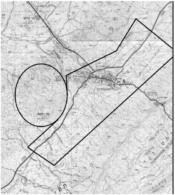
There is a very large, elongated desert plain at the base of Mount Yeroham (Figure 3). Its long axis runs northwest/southeast. It is bordered by northwest/southeast trending mountain ranges. The Yeroham Basin—the region which is drained by wadis emptying into the Yeroham reservoir at the foot of Mount Yeroham—is roughly 15 kilometers long by 7 kilometers wide. The width of this drainage area includes foothills and parts of mountains. The total width of the plain portion of this basin—the area suitable for erecting tents—is roughly 3 or 4 kilometers. A width of 3 kilometers yields a plain area of 45 square kilometers, which is greater than 11,000 acres. This is about eight times larger than the minimum requirement computed above. The hypothesis that Mount Yeroham is the Biblical Mount Sinai passes Test 4.
 |
The plain in front of Mount Sinai should be found to be littered with pottery shards today.
Archaeological sites are most easily and frequently discovered by pottery fragments lying on the ground. This results from the facts that: 1. pottery shards are of no intrinsic utility, so they tend to remain where they were originally discarded, and 2. pottery shards are very durable.
The Israelites camped at Sinai for one year. There were roughly two million Israelites camped there that year, counting women and children as well as the men. If two million Americans camped somewhere for one year, we would expect to find the ground of their campsite littered with soda cans and other garbage when they left. Similarly, the ground where the Israelites camped at Sinai would be littered with pottery shards when they left. Thus, if Mount Yeroham is the Biblical Mount Sinai, then the plain in front of the mountain should be found to be littered with pottery shards today.
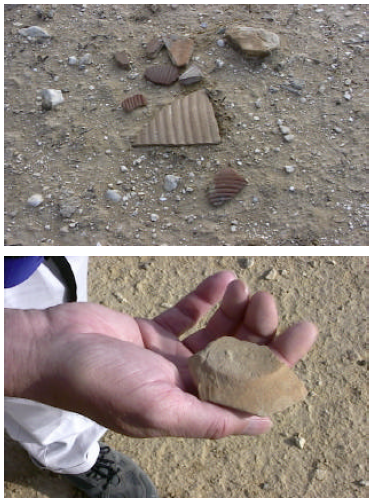
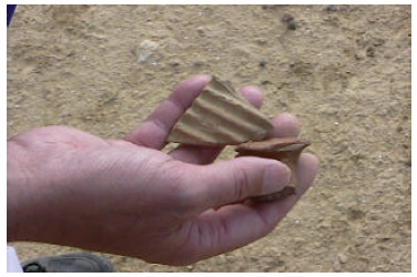
The archaeologists report that the plain at the foot of Mount Yeroham is littered with pottery shards. It is, in fact, these pottery shards which define the extent of the archaeological site at Yeroham. Philip and I walked back and forth across several acres of the plain at the foot of the mountain one morning to get a feel for the density of pottery shards in the area. We walked beside each other, several yards apart, in straight lines, calling out "piece" every time we spied a pottery shard. Intervals of silence were few and of relatively short duration—there was broken pottery everywhere. (See Figures 4 and 5.) The plain is indeed littered with pottery shards. Mount Yeroham passes Test 5.
 |
 |
There must be a source of water at Mount Sinai capable of supplying the needs of several million people year round. This follows from the fact that there were several million Israelites at Sinai and they camped there for a year. While Moses brought water from the rock at Rephidim,[12] the encampment sight prior to Sinai, no such arrangement was necessary at Sinai. This implies that Sinai had a natural, abundant source of water. If Mount Yeroham is the Biblical Mount Sinai, then Yeroham must have a natural, abundant source of water.
Yeroham does have a natural, abundant source of water. This is most clearly seen by the large reservoir at the foot of the mountain today (Figure 2). This reservoir was not as large at the time of Moses as it is today. The water from the entire drainage basin is presently impounded by a large modern dam. But the existence of this large modern dam serves to demonstrate that water is naturally abundantly available in this unique desert location. In addition to the reservoir, a well, shown on maps as "Be'er Yeroham", exists at Yeroham. The ready availability of abundant water year round at Yeroham is perhaps most clearly demonstrated by the existence of the large modern town called Yeroham on the plain a few miles from the mountain today (Figure 3). Mount Yeroham passes Test 6.
Now here is the acid test. The archaeological remains at Mount Sinai must date to the time of the Exodus. The Bible informs us that Israel was at Sinai just forty-five days following the Exodus, as noted above.
The Exodus happened roughly 2450 B.C. according to modern Biblical chronology.[13] The only physical dating method which might provide us with a calendar date for the remains at Yeroham is radiocarbon. Unfortunately, there are, so far, no radiocarbon dates from Yeroham.
Fortunately, however, it is not necessary to obtain a calendar date to perform this test. It is possible to use the style of pottery found littering the plain at Yeroham to check whether the archaeological remains at Yeroham date to the time of the Exodus.
I have previously shown—long before I heard of Yeroham—that the Exodus was the cause of the collapse of the Old Kingdom in Egypt.[14] I have also previously shown that the Conquest was the cause of the collapse of the Early Bronze III urban civilization in Palestine.[15] (See Figure 7 in the "Biblical Chronology 101" section this issue for a time chart with the archaeological time periods mentioned here.) Early Bronze III in Palestine was followed by Early Bronze IV (also called Intermediate Bronze and also, confusingly, Middle Bronze I by various archaeologists). Early Bronze IV is the period of the judges of Israel recorded in the Biblical book of Judges. The Early Bronze IV people are the Israelites. Thus, Early Bronze IV pottery is Israelite pottery.
Putting this all together, the Israelites should have been carrying a mixture of their own pottery (i.e., pottery made by their own craftsmen) and some Egyptian pottery when they came out of Egypt at the time of the Exodus. The Egyptian pottery should have been of the style used at the end of the Old Kingdom (i.e., Dynasty Six) and beginning of the First Intermediate Period, which is when the Exodus happened. Their own pottery should have been the earliest type of Early Bronze IV pottery, since the Israelites were the bearers of the Early Bronze IV culture, and this culture was first seen outside Egypt immediately following the Exodus.
Thus, if Mount Yeroham is the Biblical Mount Sinai then the pottery found ubiquitously at Yeroham should be of the style associated with the end of the Old Kingdom in Egypt and the beginning of the Early Bronze IV in Palestine.
This is exactly what is found. Even though I have looked at and handled much pottery at the base of Mount Yeroham I do not assert this on the basis of personal experience—I am untrained in the science of pottery dating. The appraisal of professional archaeologists who have conducted excavations at Yeroham, such as Moshe Kochavi in this next quote, are obviously of much greater weight:[16]
The ceramic [pottery] finds are typical of the Intermediate Bronze Age (Middle Bronze Age I) [our Early Bronze Age IV]…
Another two archaeologists, Eliezer Oren and Yuval Yekutieli, give more specific dates for the ceramics found at Yeroham. Their appraisal is that ceramics of this sort date:[17]
to the beginning of the Middle Bronze I period [our Early Bronze IV], i.e., to the period of time that in Egypt coincides with the end of the Sixth Dynasty [i.e., end of the Old Kingdom] and the beginning of the First Intermediate Period …This is precisely the right date—the hypothesis that Mount Yeroham is the Biblical Mount Sinai passes Test 7.
The preceding seven tests constitute a basic set of tests which any candidate for Mount Sinai must pass. Mount Yeroham is the only site I know of which passes these seven tests. A few examples may help to illustrate this point.
Eusebius [3rd-4th century A.D.] stated that Jebel Serbal (6,691 feet high), S of the Wadi Feiran…, was the mount of lawgiving. The valley, however, is narrow with no plain in the vicinity large enough for the year-long encampment of the 12 tribes of Israel.[18]Thus, the hypothesis that Jebel Serbal is Mount Sinai is falsified by Test 4. (It is also falsified by other of this set of seven tests, but one falsification is sufficient to invalidate a hypothesis—once a hypothesis has been falsified by one test there is no need to investigate it any further.)
The second tradition, going back to the time of Justinian (6th cen. A.D.), identifies Mount Sinai with Jebel Musa ( c. 7,500 feet high). It is one of a cluster of three peaks, Jebel Katarin ( c. 8,600 feet), lying about two miles to the SW, and Ras es-Safsafeh (6,540 feet), equidistant to the NNW. At the foot of the latter peak to the N is the only broad plain in the vicinity; it is called er-Raha, about two miles long and a half mile wide, spacious enough for the tents of all Israel.[19]
Since only Ras es-Safsafeh has a plain at its base "spacious enough for the tents of all Israel" both the hypothesis that Jebel Musa is Mount Sinai and the hypothesis that Jebel Katarin is Mount Sinai are falsified by Test 4.
But note that Ras es-Safsafeh does not do well relative to Test 4 either. A plain measuring two miles by half a mile, as er-Raha is reported to be in the quote above, is only 640 acres. This is less than half the 1,400 acres needed to accommodate the Israelites as calculated in Test 4 above. This suggests that er-Raha is very likely not "spacious enough for the tents of all Israel". But let us move on to other tests with this candidate, so as not to seem to be quibbling.
I have no data or first-hand evidence on the pottery shard density in er-Raha, so I am unable to apply Test 5 to the Ras es-Safsafeh candidacy. But I am able to apply Test 7 through the published assertion of professional Israeli archaeologist, Ram Gophna, that:[20]
no Intermediate Bronze Age [our Early Bronze IV] sites were discovered in the mountains of southern Sinai.Test 6 requires that there be a very large Intermediate Bronze Age (Early Bronze IV) site on the plain at the foot of Mount Sinai. Since there are "no Intermediate Bronze Age sites… in the mountains of southern Sinai", where Ras es-Safsafeh is situated, the hypothesis that Ras es-Safsafeh is Mount Sinai is falsified.
Archaeologist Emmanuel Anati has advanced Mount Karkom as the Biblical Mount Sinai.[21] Unfortunately, many details about the site, of importance in the present context, including its extent and chronology, are not clear, at least in The New Encyclopaedia of Archaeological Excavations in the Holy Land article by Anati on it. But there is one important fact which does seem clear enough.
Like Mount Yeroham, Mount Karkom is located in the Negev desert. However, while Mount Yeroham is located in the northern Negev, which receives roughly six inches of rainfall annually, Mount Karkom is located in the southern Negev, which receives only about two inches of rainfall annually.[22]
This immediately raises an obvious concern with this candidate—water. There is no abundant, year-round source of water at Mount Karkom. The nearest source of water today appears to be a well, Be'er Karkom, about four miles north of the mountain.
I have no data on the capacity of this well, but I would note that from the perspective of accessibility alone, an open pool seems much more likely as a water source for the Israelites than a well. To supply the needs of two million people the water source must be able to furnish enough water to meet the needs of twenty-three people each second, day and night. This does not include water for the animals. Two quarts per person per day seems a reasonable estimate of the minimum volume of water needed. This equates to a flow rate of eleven gallons of water per second, or 690 gallons per minute—about the output of 100 outdoor lawn or garden faucets running at full flow twenty-four hours per day. The well must not only be able to source this much water year round, there must also be some way of lifting the eleven gallons—ninety-six pounds—out of the well each second. A single well seems seriously inadequate to the Israelite's needs.
In addition, a topographical map of the region shows that this well would have been quite a distance from the Israelites had they camped there. The only plain, of suitable size for the tent city of the Israelites, is located to the southwest of the mountain. The distance from this plain to the well is about five miles minimum and nine miles maximum. This means that the Israelites would have needed to make a five to nine mile hike, one way, to draw water for livestock and domestic use. This would have consumed a significant fraction of each day.
I judge that Mount Karkom lacks an adequate water supply for the Israelites. Test 6 falsifies Mount Karkom.
One final candidate which is currently being promoted vigorously in some lay Christian circles is Jabal al Lawz, in Saudi Arabia.[23] This candidate is falsified by Test 3; it is located within ancient Midian, as I have previously pointed out.[24]
Having strongly corroborated the hypothesis that Mount Yeroham is the Biblical Mount Sinai through the basic set of seven tests described above, it is possible to submit it to further, site-specific tests. The idea behind each of these tests is to ask whether anything about the Yeroham site is unsuitable in any way to the Biblical record regarding Sinai.
Having now spent five days at Yeroham I am able to report that I, at least, can find nothing about the site which contradicts the Biblical account in any way. I find that Yeroham fits the Biblical record of Sinai naturally and with ease. A brief illustration of this point with respect to the two most conspicuous archaeological assemblages at Yeroham follows.
I have previously discussed the bamah, or high place, which is found on a spur of Mount Yeroham overlooking the plain.[25] All that remains of this high place today is a rock wall surrounding the crest of the spur, and some cupmarks in the bedrock surface which outcrops within the ring of stones. If Mount Yeroham is the Biblical Mount Sinai then there must be nothing about this bamah which contradicts the Biblical record.
I can now testify first hand that the bamah does not contradict the Biblical record; in fact, the bamah is strongly supportive of the picture of Sinai the Bible paints. Exodus 24:4 (NASB) records, "Then he [Moses] arose early in the morning, and built an altar at the foot of the mountain [Mount Sinai] with twelve pillars for the twelve tribes of Israel". The bamah at Yeroham suits Exodus 24:4 very well. It is appropriately situated "at the foot of the mountain". It is also suitably situated for the sealing-of-the-covenant ceremony which Exodus 24 records was enacted at Moses' altar. Moses acted as mediator between God and the people in this covenant ceremony. The high place at Yeroham is up high enough to overlook the entire plain below, where the people were camped. Yet it is well below the summit of the mountain, where the glory of the Lord appeared "like a consuming fire on the mountain top" (Exodus 24:17, NASB). Thus, it was suitably located on middle ground, between God and the people.
The only domestic structures found at Yeroham by the archaeologists are remains of dry-laid stone buildings located on another spur of the mountain to the north of the bamah (Figure 2). The archaeologists have called this collection of buildings the "main settlement". They have excavated a portion of these buildings and found characteristic Early Bronze IV pottery there, like the pottery found on the plain. They uncovered two strata at the site. This is, apparently, the only case having buildings of this sort in this time period in which more than one stratum has been found. Buried in the remains of one of the dwellings of the upper stratum,
a hoard of eighteen copper ingots with low lead content was found. These suggest the existence of a metal industry…[26]
If Mount Yeroham is the Biblical Mount Sinai then there must be nothing about these "main settlement" remains which contradicts the Biblical record.
Here again, far from contradicting the Biblical record, everything about the "main settlement" seems to harmonize immediately with the Biblical account of the Israelites' stay at Sinai.
The existence of the "main settlement" buildings, distinct in construction and location from the Israelite tent city on the plain below the mountain, finds explanation in the Biblical record of the presence of Moses' Midianite relatives, an ethnic group distinct from the Israelites, at Sinai. We learn from the Bible that they were not under Moses' leadership. This is shown by Hobab's statement that he would return to his land and his relatives, quoted above, and by Moses' request, rather than command, that Hobab remain with them.[27] Thus it is not surprising to find them situated on a spur of their own, away from the Israelite camp.
The evidence of a copper industry within the Midianite village at Yeroham also fits the Biblical record. Jethro, Moses father-in-law, is described in Judges 1:16 as a Kenite. "Kenite" means metal smith:[28]
The term "Kenite" comes from qayin, which originally meant "metalworker, smith," as in Aram. and Arabic. … The Kenites apparently were nomadic or seminomadic clans of smiths…Thus Moses' in-laws were metal-working, Midianite nomads.
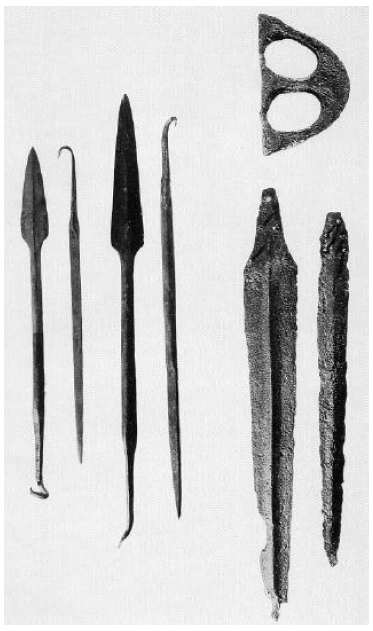
With this in mind we can begin to understand Moses' in-laws interest in the Israelites at Sinai. Here were hundreds of thousands of former slaves equipping for the conquest of Canaan. Typical weapons of the Early Bronze IV period (i.e., Israelite weapons following the Exodus) are shown in Figure 6.[29] These were made of copper, or copper alloyed with a small percentage of arsenic (arsenic bronze). Clearly, the Midianite presence at Sinai benefited both the Israelites, who needed weapons, and the Midianites, who made their living, in part, by crafting copper.
 |
The style and situation of the "main settlement" dwellings excavated by the archaeologists at Yeroham also harmonize immediately with what we learn of the Midianite/Kenites from the Bible. Numbers 24:21 (NASB) says of the Kenites, "Your dwelling place is enduring, and your nest is set in the cliff". I have now been to Yeroham and spent part of a day walking around in these "main settlement" dwellings. I can testify that "nest" is an apt description of these buildings, and that they are indeed "set in the cliff". At one point I had to caution Philip not to step backwards while filming these buildings, for fear of losing him into the ravine below.
Another puzzle piece which fits immediately with the Biblical picture is that of the existence of two strata within the "main settlement". An explanation of this apparently unique occurrence at Yeroham is afforded by the Biblical record of a severe earthquake at the mountain while the Israelites were camped there.[30] This raises the possibility that the lower stratum may be from the period of time before the earthquake—that the lower stratum buildings were destroyed by the earthquake—and that the upper stratum represents buildings and structures built above the ruins of the original settlement following the earthquake.
The true site of Mount Sinai has been a source of speculation for most, if not all, of the Christian era. Given the very large number of mountains in the deserts to the east of Egypt it is little wonder that past speculations have failed to reveal the correct mountain.
But the era of uncontrolled speculation has now passed away. Modern techniques of accurately mapping large areas, coupled with extensive archaeological surveys of the Sinai peninsula and the Negev of Israel carried out within the past three or four decades, have provided scholar and layperson alike with a wealth of easily accessible, factual data about these regions for the first time in history. These factual data, when coupled with modern results from the field of Biblical chronology, rapidly eliminate all but one candidate, including several of ancient acclaim.
The lone surviver is Mount Yeroham—the true Mount Sinai, found at long last. ◇
I presented the following talk at the 17th International Radiocarbon Conference in Israel in June. I have included it this issue in this column for two reasons. First, it serves as a helpful overview and review of material covered in greater depth and detail previously in The Biblical Chronologist. Second, many subscribers have closely followed the work it describes and some have actively participated in its support. It seems appropriate that they should share in what was said.
The conference lasted one week and was attended by hundreds of scientists from around the world. Session topics included calibration of the radiocarbon time scale, radiocarbon instrumentation, the application of radiocarbon and other cosmogenic isotopes to the modern environment, archaeology, Near East chronology (the session in which the following talk was presented), global climate, and others.
My presentation was titled "New Radiocarbon Dates for the Reed Mat from the Cave of the Treasure, Israel".
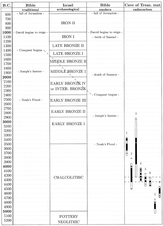
Most of what I have to say today is shown on this time chart (Figure 7).
 |
My background is in physics, with a Ph.D. in A.M.S. [Accelerator Mass Spectrometry—a technique which uses nuclear physics instrumentation to radiocarbon date extremely small samples.] from the University of Toronto back in the early eighties. But my absorbing interest for decades has been Biblical chronology.
Biblical chronology seems to me to be the one independent dating method which is being largely neglected at the present time. It had a very prominent place some few generations ago, but it did not do very well, and it is being basically ignored at the present time.
It's through this interest in Biblical chronology that I became involved in redating the Cave of the Treasure mat. I want to explain a little bit of how this has come about, and then go into some of the new dates on the mat.
What I've shown in this time chart (Figure 7) is a typical traditional Biblical chronology along side a typical chronology of the archaeology of Israel. These are both just typical—as I read various scholars in these fields I find that there is quite a lot of variation, not only in the boundaries of the different time periods, but also even in the naming conventions used for them. But the chronologies shown here are typical, and should be sufficient to illustrate what I'm trying to say here this morning.
A typical traditional Biblical chronology looks like this: it has the fall of Jerusalem just after 600 B.C., the Conquest of Canaan by the Israelites around 1400 B.C., Joseph's famine around 1900 B.C., and Noah's Flood around 2500 B.C. I've specifically chosen these five events, from quite a range of possible events that could be chosen from the Biblical narrative, because each of these five events has the property of being archaeologically detectable. The fall of Jerusalem should certainly yield archaeologically detectable results. The origin of the monarchy should also be detectable archaeologically. The Conquest is pictured Biblically as the destruction of an urban civilization—the Canaanite civilization—and the overrunning of the land by a tribally organized, pastoral, nomadic people—the Biblical Israelites. It certainly should be seen archaeologically if it is real. Joseph's famine is depicted as a very severe seven-year famine which totally impoverished countries around Egypt, according to the Biblical narrative. It should be able to be detected archaeologically if it happened. And Noah's Flood, of course, is depicted Biblically as a Flood event which wiped out the population almost entirely, with only a few survivors. It should certainly be detectable archaeologically.
If we ask how this traditional Biblical chronology has worked out relative to the reconstruction of history that comes out of archaeology, the answer is somewhat mixed.
Back nearly to 1000 B.C. there is generally good agreement.
As you know, there is a debate going on right now, near 1000 B.C., about the historicity of Solomon and David.
Prior to 1000 B.C. there is no agreement at all anywhere: certainly it's the case that nothing suitable to the Conquest happens anywhere in the Late Bronze Age; there is no famine of the right sort during Middle Bronze I; and certainly there is no Flood in Early Bronze III—it is ludicrous to suppose that any kind of major decimation of population could have happened anywhere in the Early Bronze III.
This track record of total lack of agreement prior to 1000 B.C. has led to a general consensus among scholars that the history of the Bible in this period of time is simply not valid—that it is mythological, fabricated, or whatever.
I disagree with this consensus. I find that it is not the history of the Bible which is not valid, but the chronology which is messed up, and it is messed up in a very major way.
The chronology of the Bible between the time of Solomon and the Exodus depends entirely upon one number in one verse—1 Kings 6:1. That verse says that there was 480 years between the Exodus and the building of the temple in Solomon's fourth year.
I feel that sane reasoning cannot help but conclude that the number, "480", was originally "1,480".
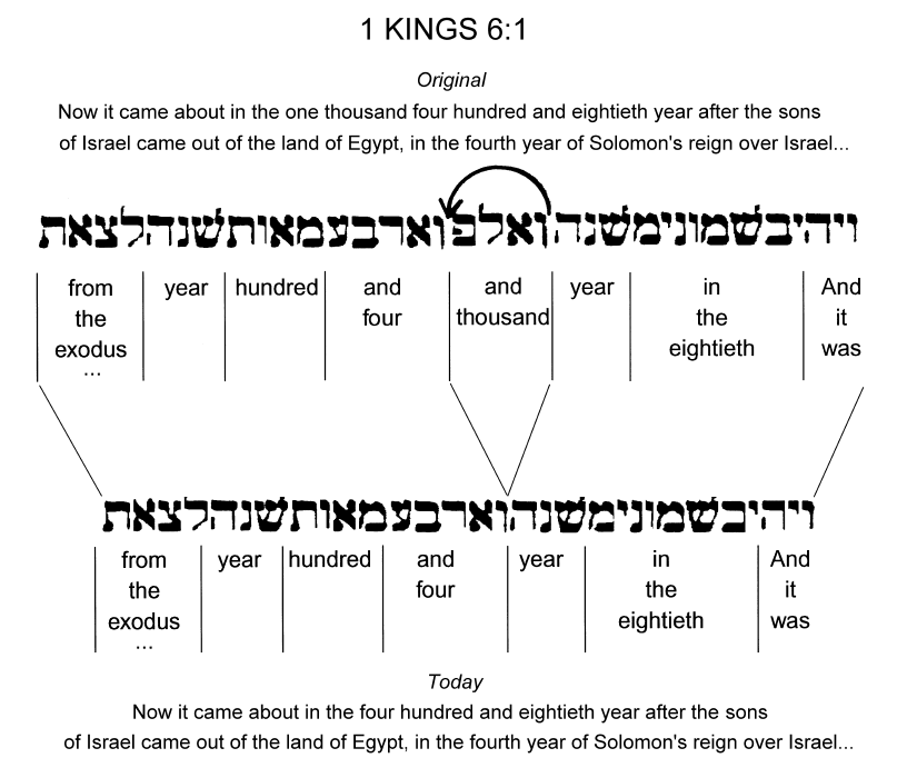
How the hypothesized "1,480" came to be "480" is shown on the back of the handout I gave you (Figure 8). 1 Kings 6:1 reads today as shown here (bottom of Figure 8): "Now it came about in the four hundred and eightieth year after the sons of Israel came out of the land of Egypt, in the fourth year of Solomon's reign over Israel…" that Solomon began to build the temple. In Hebrew it looks as shown here (bottom line of Hebrew in Figure 8): "And it was – in the eightieth – year – and four – hundred – year – from the exodus…" It seems impossible to conclude otherwise than that the Hebrew originally had a "thousand" years in here (top line of Hebrew in Figure 8): "And it was – in the eightieth – year – and thousand – and four – hundred – year – from the exodus…", and that in the process of copying this verse some long time ago the scribe accidentally skipped over from these two characters to where they are repeated, leaving out this thousand years.
 |
This is a minor copy error. Copy errors of this sort can be unambiguously demonstrated from various extant Old Testament manuscripts.
It is a very tiny copy error, but it has resulted in a very major chronological error in Biblical chronology, which has not been recognized traditionally.
If you put this missing thousand years back into the chronology, which is what I've done here, in this column (third column of Figure 7)—I have simply added in the additional thousand years, which moves the Conquest down near 2400 B.C., Joseph's famine down near 2900 B.C., and Noah's Flood down near 3500 B.C.—it totally changes the outlook for the historicity of these Biblical events.
The Conquest, for example, does find a natural setting near 2400 B.C. in Biblical archaeology and secular history. We're expecting to find, from the Bible, at the Conquest, the destruction of an urban Canaanite civilization in Palestine. The Early Bronze III civilization is an urban civilization. The Early Bronze IV, or Intermediate Bronze, results from the destruction of that urban civilization everywhere in the land, and its replacement by a tribally organized, pastoral, nomadic people. This "thousand years" correction says that the Intermediate Bronze people are the Biblical Israelites.
Joseph's famine also moves one thousand years earlier than traditional expectations. Here again, at the earlier date, a natural match to the archaeological record is found. The transition shown here between Early Bronze I and Early Bronze II is the one at which all the sites of the Early Bronze shrink in size. Megiddo, for example, shrinks from 160 acres down to something like 13 acres at this time. The population of Megiddo shrinks from 9,000 down to 900 or 1,000. This shrinkage of the Early Bronze population is seen throughout the land. This is the only geographically extended transition of any sort in Early Bronze I through Early Bronze III that I've been able to find, reading what the archaeologists have to say about it. It is at the same time—within the dating uncertainties that are involved here—as Joseph's famine.
Most shockingly—it took me five years to come to see this after having found that a "thousand" years had gotten dropped out of the Biblical text—even the Flood finds a natural setting archaeologically when moved back one thousand years earlier than traditional expectations.
I'm sure those who are archaeologists here know that the transition between the Chalcolithic and the early Bronze is unique in that it appears that the Chalcolithic people, to a very large extent, vanished at the end of the Chalcolithic. Civilization starts over again at the beginning of the Early Bronze. This is the fundamental requirement of Noah's flood. It is pictured Biblically as a catastrophe in which the population is nearly exterminated and only a very few people remain to start over again afterwards.
The temporal coincidence between the Biblical date of Noah's Flood, when once the missing "thousand" years are restored, and the archaeological date of the end of the Chalcolithic period in Palestine is obviously of great interest. I've spent a number of years now examining it, and asking the question, "Do we really have a synchronism between the Biblical Flood event and this transition?"
And that's how I got into redating the Cave of the Treasure's mat.
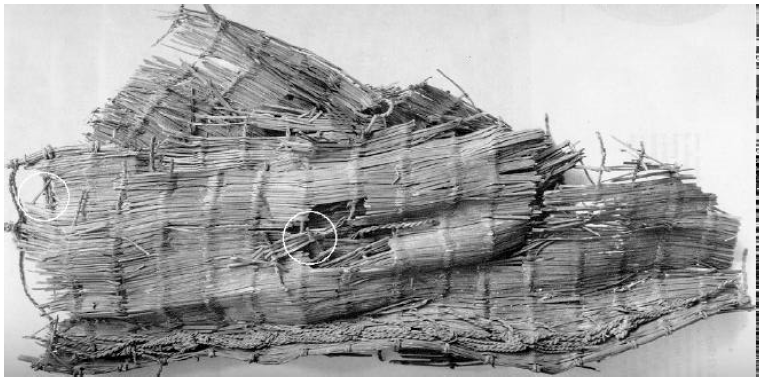
The Cave of the Treasure mat looked like it would perhaps be the best single sample to use to radiocarbon date the end of the Chalcolithic. I was hoping to refine the date of the terminal Chalcolithic by a more careful dating program on this mat.
What I'm showing here (Figure 9) are radiocarbon dates that were made on the Cave of the Treasure mat, plus one date on a piece of wood that was found in association with the mat, back in the 1960's when the mat was first discovered by Pessah Bar-Adon and his archaeological team working in the Judean desert. The top three are on the mat, and this one, I-353, is on a piece of wood associated with the mat.
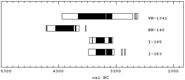 |
These dates appeared to be giving a reasonable indication that the Cave of the Treasure mat had originated near the end of the Chalcolithic. You can see that three of them are in harmony, near 3500 B.C., and one is an older date which appears to be an outlier.
The stratigraphy in the cave, the nature of the objects found with the mat, and several other indications all seemed to suggest that the mat had originated just prior to the close of the Chalcolithic.
So I began to seek permission to have the mat redated, and I was ultimately granted that permission by the Israel Antiquities Authority.
Unfortunately, I have been totally frustrated in my efforts to refine the date of the terminal Chalcolithic using this mat. I find, in fact, that the mat does not originate at the end of the Chalcolithic at all.
 |
The fourth column (Figure 7) shows the three 1960's radiocarbon dates on the mat together with five new radiocarbon dates on the mat. The two dates, 4 and 5, are sister samples, and they show good agreement. (We're using CALIB 4 here for these date ranges; the black bars show 1σ ranges and the open bars are 2σ ranges.) Sample 6 is from the straw weft that was used on the mat. Samples 7 and 8 are also sister samples. They are on reeds from the mat. They do not agree with the other dates, and they also don't agree internally, so there is something wrong with this particular reed sample. We don't understand what it is yet. But if we ignore samples 7 and 8 we do get a general indication that the correct date for this mat is in the middle of the Chalcolithic, not at the end of the Chalcolithic at all. If we average these four samples (2, 4, 5, and 6), we get a date within 50 years, 2σ, of 4300 B.C.
So my effort to refine the radiocarbon date of the end of the Chalcolithic has come to nothing, but I did discover something quite interesting about the Cave of the Treasure mat—that it is much older than previously thought—and perhaps that is a happy ending of its own sort. Thank you.
The talk was cordially received by the scientists present, including Israeli archaeologists. There was much background chatter at several points during the talk, especially during the discussion of the synchronization of the Flood with the end of the Chalcolithic. I didn't hear what was being said between members of the audience, of course—I imagine it was something like, "Can this possibly be true?!" After the talk one older scientist said, in private conversation, "What you have discussed is very interesting, and looks like it may very well be true". I judge we are making progress in communicating the fact of the missing millennium in 1 Kings 6:1 and its positive implications for the historicity of the Bible. ◇
The "Biblical Chronology 101" article this issue reports the results of The Cave of the Treasure mat redating project current to the middle of June.[31] Further work continues on one sample of reeds from the mat which has not yielded reproducible results. We hope to learn whether the problem is with the sample itself or is a result of a lab error of some sort. Once this loose end has been sewn up, the project will be officially complete.
The curator of the Cave of the Treasure mat, Ms. Osnat Misch-Brandl, has broached the possibility of further joint effort with The Biblical Chronologist to have food items (e.g., seeds) excavated within the Cave of the Treasure radiocarbon dated. This is of interest to Biblical chronology for the following reason.
Our purpose for dating the mat was to try to refine the secular date of the end of the Chalcolithic in Israel, because of the synchronism between it and the Biblical date of Noah's Flood. The new dates on the mat seem to show that it originates in the middle of the Chalcolithic rather than at the end of the Chalcolithic, thwarting this purpose.
However, the possibility remains that the mat may have been buried at the end of the Chalcolithic. Since the copper items found with the mat seem to have been religious objects, it is possible that the mat was not of ordinary, everyday use either, but rather was of some ancient religious significance as well. It may have been preserved for hundreds of years for this reason, prior to being buried in the cave.
Dating food items found discarded within the stratified dirt floor of the cave would be the best way of testing this hypothesis. If the mat was buried at the close of the Chalcolithic—in hopes of preserving it and its contents at the onset of the Flood, for example—then radiocarbon dates on short-lived food samples from the cave should show this, and might enable us to achieve our original goal of refining the secular date of the terminal Chalcolithic after all.
Discussions regarding this potential research project are underway with Ms. Misch-Brandl.
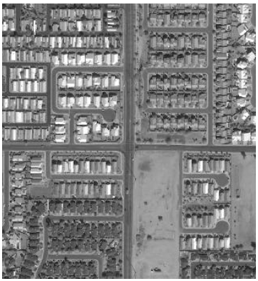 |
The order for two commercial satellite photos of the south side of Mt. Cilo, where IO3 was photographed in the 1960s, has now been accepted.[32] I hope to have modern, high resolution (1-meter) images of IO3 to share by the time the next issue of The Biblical Chronologist goes to press. Nothing is guaranteed at this point, however. There are a number of factors beyond our control which may yet hinder acquisition of suitable photos. These include cloud cover in the area when the satellite passes overhead, and snow cover on the ground, for example.
The major objective with these photos is to see if IO3 is still there on the side of Mount Cilo. If it is, we hope to learn more about its true nature—specifically, whether it is remains of the ark, or some other natural or man-made object. ◇
The Biblical Chronologist is a bimonthly subscription newsletter about Biblical chronology. It is written and edited by Gerald E. Aardsma, a Ph.D. scientist (nuclear physics) with special background in radioisotopic dating methods such as radiocarbon. The Biblical Chronologist has a threefold purpose: to encourage, enrich, and strengthen the faith of conservative Christians through instruction in Biblical chronology, to foster informed, up-to-date, scholarly research in this vital field within the conservative Christian community, and to communicate current developments and discoveries in Biblical chronology in an easily understood manner. An introductory packet containing three sample issues and a subscription order form is available for $9.95 US regardless of destination address. Send check or money order in US funds and request the "Intro Pack." The Biblical Chronologist (ISSN 1081-762X) is published six times a year by Aardsma Research & Publishing, 412 N Mulberry, Loda, IL 60948-9651. Copyright © 2000 by Aardsma Research & Publishing. Photocopying or reproduction strictly prohibited without written permission from the publisher.
|
^ The days spent at Yeroham were Saturday, June 17, the morning of Sunday, June 18, and then Saturday through Tuesday, June 24–27. June 19–23 I attended the 17th International Radiocarbon Conference held a few kilometers outside of Jerusalem. (The talk I presented at the conference comprises the "Biblical Chronology 101" column this issue.)
^ Gerald E. Aardsma, "Yeroham—The True Mt. Sinai?" The Biblical Chronologist 1.6 (November/December 1995): 1–8.
^ Gerald E. Aardsma, A New Approach to the Chronology of Biblical History from Abraham to Samuel, 2nd ed. (Loda IL: Aardsma Research and Publishing, 1993).
^ Gerald E. Aardsma, "The Bamah of Moses at Mount Sinai" The Biblical Chronologist 6.3 (May/June 2000): 1–10.
^ See Numbers 33:3 and Exodus 19:1.
^ Gerald E. Aardsma, "The Route of the Exodus," The Biblical Chronologist 2.1 (January/February 1996): 1–9.
^ Exodus 17:8–13.
^ Exodus 19:1–3.
^ Exodus 19:1, NASB.
^ Exodus 19:2.
^ Exodus 12:37.
^ Exodus 17:1–7.
^ Gerald E. Aardsma, A New Approach to the Chronology of Biblical History from Abraham to Samuel, 2nd ed. (Loda IL: Aardsma Research and Publishing, 1993); Gerald E. Aardsma, "Chronology of the Bible: 3000–1000 B.C.," The Biblical Chronologist 1.3 (May/June 1995): 1–3.
^ Gerald E. Aardsma, A New Approach to the Chronology of Biblical History from Abraham to Samuel, 2nd ed. (Loda IL: Aardsma Research and Publishing, 1993); Gerald E. Aardsma, "The Chronology of Egypt in Relation to the Bible: 3000–1000 B.C.," The Biblical Chronologist 2.2 (March/April 1996): 1–9.
^ Gerald E. Aardsma, A New Approach to the Chronology of Biblical History from Abraham to Samuel, 2nd ed. (Loda IL: Aardsma Research and Publishing, 1993); Gerald E. Aardsma, "The Chronology of Palestine in Relation to the Bible: 3000–1000 B.C.," The Biblical Chronologist 1.4 (July/August 1995): 1–6.
^ Moshe Kochavi, "Mount Yeroham," The New Encyclopedia of Archaeological Excavations in the Holy Land, vol. 4, ed. Ephraim Stern (New York: Simon & Schuster, 1993), 1507.
^ E. D. Oren and Y. Yekutieli, "North Sinai During the MB I Period—Pastoral Nomadism and Sedentary Settlement," Eretz-Israel 21 (1990): 16. (English translation provided by Marganit Weinberger-Rotman.)
^ Alice Wonder, "Sinai," Wycliffe Bible Encyclopedia, vol. 2, ed. Charles F. Pfeiffer, Howard F. Vos, John Rea (Chicago: Moody Press, 1975), 1597.
^ Alice Wonder, "Sinai," Wycliffe Bible Encyclopedia, vol. 2, ed. Charles F. Pfeiffer, Howard F. Vos, John Rea (Chicago: Moody Press, 1975), 1597.
^ Ram Gophna, "The Intermediate Bronze Age," The Archaeology of Ancient Israel, ed. Amnon Ben-Tor (New Haven: Yale University Press, 1992), 135.
^ Emmanuel Anati, "Karkom, Mount," The New Encyclopaedia of Archaeological Excavations in the Holy Land, vol. 3 (New York: Simon & Schuster, 1993), 850–851.
^ Nelson Glueck, Rivers in the Desert: A History of the Negev, Evergreen Encyclopedia Volume 5, (New York: Grove Press, Inc, 1959), map following page 20.
^ Larry R. Williams, The Mount Sinai Myth (New York: Wynwood Press, 1990).
^ Gerald E. Aardsma, "Biblical Chronology 101," The Biblical Chronologist 2.2 (March/April 1996): 9–12.
^ Gerald E. Aardsma, "The Bamah of Moses at Mount Sinai" The Biblical Chronologist 6.3 (May/June 2000): 1–10.
^ Moshe Kochavi, "Yeroham, Mount," The New Encyclopedia of Archaeological Excavations in the Holy Land, vol. 4, ed. Ephraim Stern (New York: Simon & Schuster, 1993), 1507.
^ Numbers 10:29–32.
^ John Rea, "Kenite," Wycliffe Bible Encyclopedia, vol. 2, ed. Charles F. Pfeiffer, Howard F. Vos, John Rea (Chicago: Moody Press, 1975), 986.
^ The Archaeology of Ancient Israel, ed. Amnon Ben-Tor (New Haven: Yale University Press, 1992), plate 23.
^ Exodus 19:18.
^ For background on this research project see: Gerald E. Aardsma, "Radiocarbon Dating Noah's Flood," The Biblical Chronologist 3.6 (November/December 1997): 1–11, and Gerald E. Aardsma, "Radiocarbon Dating Noah's Flood – Part II" The Biblical Chronologist 6.2 (March/April 2000): 1–11.
^ See Gerald E. Aardsma, "Research in Progress," The Biblical Chronologist 5.3 (May/June 1999): 7–16 for background on this research project.