
| |
| Volume 14, Number 9 | June 11, 2024 |
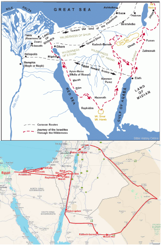
What we have learned so far about the path taken by the Israelites of the Exodus from Egypt to Canaan was shown last issue.[1] There, it was noted that the final leg of this path, from Kadesh-barnea to Canaan, departs radically from traditional expectations (Figure 1). Is this radically different path to be trusted? Is it correct? The location of the final "Red Sea" of the Exodus says yes.
 |
"Red Sea" is mentioned multiple times in the Exodus journey. Unfortunately, "Red Sea" is a mistaken translation of the original Hebrew yam suph, and this mistaken translation adds much confusion to the biblical historical account of the route of the Exodus. The correct translation of yam suph is "reed sea" or "sea of reeds," as previously discussed.[2]
A reed sea refers to a body of salty water surrounded by reeds. There were several reed seas, not a singular "Reed Sea," involved in the Exodus journey.
In a desert or semi-desert environment, a reed sea may be expected to result wherever sufficient freshwater runoff accumulates in a large depression in the ground having little or no outlet. Rainwater running into the depression will form a pond or lake. The rainwater will pick up soluble salts from the soil as it runs across the ground, and these salts will remain behind in the depression as water evaporates. Thus, the water in the pond or lake will become saline, creating a salty body of water. Meanwhile, the freshwater runoff entering the pond or lake will provide sufficient fresh water to the marshy margins of the saline water body for reeds, which are freshwater plants, to be able to grow.
The first mention of "Red Sea" within the Exodus narrative refers to the well-known "Red Sea" Crossing event, which occurred fairly soon after the Israelites had left Egypt.
Hence God led the people around by the way of the wilderness to the Red Sea; and the sons of Israel went up in martial array from the land of Egypt. (Exodus 13:18)
The correct translation of this verse is:
Hence God led the people around by the way of the wilderness to the reed sea; and the sons of Israel went up in martial array from the land of Egypt. (Exodus 13:18)
We now know that the specific yam suph or reed sea involved in the Crossing event corresponds to the modern Ar Ruwaj lagoon of Lake Bardawil.[3]
"Red Sea" is mentioned again as the distinguishing landmark of the sixth encampment after leaving Egypt, giving this encampment its name.
And they journeyed from Marah, and came to Elim; and in Elim there were twelve springs of water and seventy palm trees; and they camped there. And they journeyed from Elim and camped by the Red Sea. And they journeyed from the Red Sea, and camped in the wilderness of Sin. (Numbers 33:9–11)
The correct translation of these verses is:
And they journeyed from Marah, and came to Elim; and in Elim there were twelve springs of water and seventy palm trees; and they camped there. And they journeyed from Elim and camped by the reed sea. And they journeyed from the reed sea, and camped in the wilderness of Sin. (Numbers 33:9–11)
This reed sea would have been located in the northeast corner of Makhtesh Yeruham back at the time of the Exodus, as previously explained.[4]
The "Red Sea" of interest in the present context is mentioned in connection with the final leg of the journey from Egypt to Canaan.
Then they set out from Mount Hor by way of the Red Sea, to go around the land of Edom; and the people became impatient because of the journey. (Numbers 21:4)
The correct translation of this verse is:
Then they set out from Mount Hor by way of the reed sea, to go around the land of Edom; and the people became impatient because of the journey. (Numbers 21:4)
This mention of "the reed sea" is similar to the "the reed sea" Crossing mention in that both are associated with a "way," that is, a road.
In the case of the reed sea Crossing event, the referenced road is the North Sinai road (modern Route 40) which skirts the south side of Lake Bardawil, the referenced reed sea.
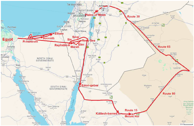
The Numbers 21:4 "way of the reed sea" road (see Figure 2) was identified in the previous issue as corresponding to Route 15 going east out of Tabuk, which becomes Route 80 going northeast, turns northwest along Route 65, and becomes Route 30 when it leaves Saudi Arabia and enters Jordan. If this "way of the reed sea" identification is correct, then there should be evidence for a conspicuous, landmark sea of reeds somewhere along this road back at the time of the Exodus.
 |
And indeed there is.
The final reed sea of the Exodus cannot be located by looking for it on a modern satellite image. The problem is that the climate in this region has become significantly more arid than it was back at the time of the Exodus. This fact has been seen repeatedly in this series. Most recently, it has been observed that few if any reeds surround Lake Bardawil at present, and neither reeds nor standing water body of any sort at all can be observed within the modern Makhtesh Yeruham.[5] Decreased rainfall in the region since the time of the Exodus has resulted in insufficient freshwater input to bodies of salty water to maintain the growth of reeds at their margins and to keep them from drying up completely for much if not all of the year.
To find the ancient reed sea we are seeking, it is necessary to look for a suitable depression in the ground where a reed sea would be expected to form in a climate similar to that which pertained at the time of the Exodus, a climate with more rainfall than is observed there in modern times.
This can be done fairly easily today using a modern topographic map. Figure 3 shows the result. The important thing to notice is that Route 65/30 runs in a valley that is a suitable depression for a reed sea. It is shut in, with no exit for runoff lower than about 1,900 feet elevation. Since the bottom of this large depression has an elevation of roughly 1,700 feet, this valley would fill to form a lake roughly 200 feet deep, given sufficient rainfall.
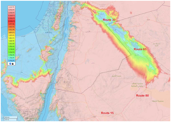 |
There was not enough rainfall back at the time of the Exodus to create such a lake, but there appears to have been enough to create a reed sea in the bottom of this valley. I suggest that the modern road through this valley runs for much of its length in the same place as the ancient road ran back at the time of the Exodus, and I suggest that the ancient road skirted the reed sea which then occupied the floor of this valley.
This ancient reed sea would have been very long. The valley itself is roughly 200 miles long. Thus, this ancient reed sea would have been an unmistakable landmark. It would have been natural and appropriate to refer to it as "the reed sea" even though it may have been broken into subunits, as is true of Lake Bardawil, and it would have been natural and appropriate to refer to the road which led to it and ran for many miles beside it as "the way of the reed sea."
The final "Red Sea" of the Exodus finds a simple and natural understanding as the reed sea which in less arid ancient times must have filled the bottom of the valley through which the modern Route 65/30 runs.
Last issue, this road was seen to be the path which the Israelites of the Exodus must have taken from Kadesh-barnea through Mount Hor on the final leg of their journey to Canaan, despite the fact that this path departs radically from traditional expectations. The location of the final "Red Sea" of the Exodus identified this issue provides independent evidence in support of this path.
But there is more. This conclusion, while valid and helpful, is anemic relative to what the biblical historical record affords. It is possible to carry the logic forward a little further to a stronger conclusion.
Once again, the text says:
Then they set out from Mount Hor by way of the reed sea, to go around the land of Edom; and the people became impatient because of the journey. (Numbers 21:4)
If every road from Mount Hor sported a reed sea along the way, then it would not be meaningful to designate any one of them as "the way of the reed sea." For this designation to be meaningful, only one road between Mount Hor and Canaan can sport this feature. Said simply, for "the way of the reed sea" to be a meaningful designator of a specific road, logic demands that there be one, and only one, road from Mount Hor to Canaan sporting a reed sea.
We have now found one road between Mount Hor and Canaan which must have sported a reed sea back at the time of the Exodus. With reference to Figure 2, this is Route 15 east out of Tabuk/Kadesh-barnea through Mount Hor, turning onto Route 80 going northeast, and then turning northwest onto Route 65/30. Logic demands that this road must be the one and only "way of the reed sea" which the Israelites took from Mount Hor to Canaan. ◇
The Biblical Chronologist is written and edited by Gerald E. Aardsma, a Ph.D. scientist (nuclear physics) with special background in radioisotopic dating methods such as radiocarbon. The Biblical Chronologist has a fourfold purpose:
The Biblical Chronologist (ISSN 1081-762X) is published by: Aardsma Research & Publishing Copyright © 2024 by Aardsma Research & Publishing. Scripture quotations taken from the (NASB®) New American Standard Bible®, Copyright© 1960, 1971, 1977, 1995 by The Lockman Foundation. Used by permission. All rights reserved. www.Lockman.org } |
^ Gerald E. Aardsma, "The Route of the Exodus, Part XI: The Location of the Plains of Moab Encampment (and the Path Taken to Get There)," The Biblical Chronologist 14.8 (May 28, 2024): 1–6. www.BiblicalChronologist.org.
^ Gerald E. Aardsma, "The Route of the Exodus, Part X: The Location of the 'Red Sea' Encampment (and the Meaning of Yam Suph)," The Biblical Chronologist 14.4 (February 13, 2024): 1–5. www.BiblicalChronologist.org.
^ Gerald E. Aardsma, "Understanding the Red/Reed Sea Crossing," The Biblical Chronologist 13.6 (July 11, 2023): 1–8. www.BiblicalChronologist.org.
^ Gerald E. Aardsma, "The Route of the Exodus, Part X: The Location of the 'Red Sea' Encampment (and the Meaning of Yam Suph)," The Biblical Chronologist 14.4 (February 13, 2024): 1–5. www.BiblicalChronologist.org.
^ Gerald E. Aardsma, "The Route of the Exodus, Part X: The Location of the 'Red Sea' Encampment (and the Meaning of Yam Suph)," The Biblical Chronologist 14.4 (February 13, 2024): 1–5. www.BiblicalChronologist.org.