
| |
| Volume 14, Number 7 | April 30, 2024 |
In the Old Testament, an ascent is a road with an upward grade. The poetic parallelism of Isaiah 15:5b provides a defining example:
For they go up the ascent of Luhith weeping;
Surely on the road to Horonaim they raise a cry of distress over their ruin.
Knowledge of the location of the ascent of Akrabbim, mentioned by Moses in relation to the southern border of Israel (Numbers 34:4), appears to have been lost to history thousands of years ago, making it another unsolved mystery of the Exodus.
Unfortunately, the prevalence of hilly topography and cliffs in and around Israel supplies a large number of potential candidates for the ascent of Akrabbim. One may spend a lot of time guessing which ascent corresponds to Akrabbim and still not get it right.
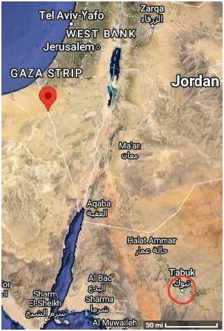
The knowledge that Kadesh-barnea is to be identified with Tabuk, Saudi Arabia,[1] (Figure 1) allows this longstanding mystery now to be solved. Conversely, the solution of this longstanding mystery corroborates the identification of the biblical Kadesh-barnea with modern Tabuk.
 |
Very near the end of Moses' long life, having recently defeated the Transjordan Amorites and having apportioned their land to the tribes of Gad, Reuben, and the half-tribe of Manasseh, God specified, through Moses, the land remaining to be apportioned to the Israelites:
Then the Lord spoke to Moses saying, "Command the sons of Israel and say to them, 'When you enter the land of Canaan, this is the land that shall fall to you as an inheritance, even the land of Canaan according to its borders. Your southern sector shall extend from the wilderness of Zin along the side of Edom, and your southern border shall extend from the end of the Salt Sea eastward. Then your border shall turn direction from the south to the ascent of Akrabbim, and continue to Zin, and its termination shall be to the south of Kadesh-barnea …' " (Numbers 34:1–4a)
To understand where in the world the geography referred to in these verses is located, it is essential to know that Kadesh-barnea is not located in the Negev, where it has traditionally been situated, but very much farther south at the modern Tabuk in Saudi Arabia (Figure 1). Not knowing this gets most translations of these verses into more or less immediate trouble. The "Salt Sea" is then necessarily seen as the Dead Sea (Figure 2), there being no other nearby salt water body having an "end" from which to begin to draw a border line. The Amplified Bible, for example, makes this explicit: "from the end of the Salt (Dead) Sea eastward."
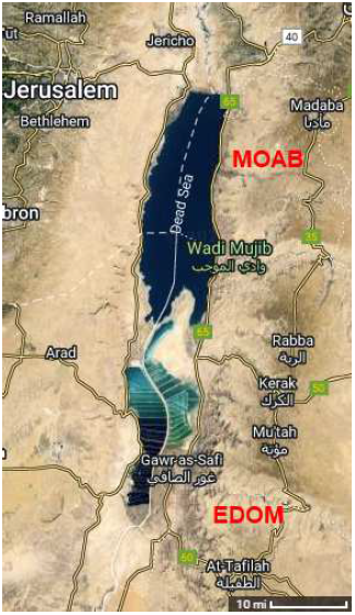 |
According to the verses from Numbers quoted above, this makes Israel's southern border to include a line stretching eastward from either the north end or the south end of the Dead Sea: "your southern border shall extend from the end of the [Dead] Sea eastward."
But God cannot be placing Israel's southern border at the south end of the Dead Sea because this would run the southern border of Israel through Edom, the land of Esau, whose land God had specified the Israelites of the Exodus were not to take.
You have circled this mountain long enough. Now turn north, and command the people saying, "You will pass through the territory of your brothers the sons of Esau who live in Seir; and they will be afraid of you. So be very careful; do not provoke them, for I will not give you any of their land, even as little as a footstep because I have given Mount Seir to Esau as a possession." (Deuteronomy 2:3–5)
This leaves only the north end of the Dead Sea, but it fares no better. The "plains of Moab" are specified as being opposite Jericho, and Jericho is situated several miles farther north than the north end of the Dead Sea. So this runs the southern border of Israel through Moab, and, once again, this land was forbidden to the Israelites of the Exodus.
"Then the Lord said to me, 'Do not harass Moab, nor provoke them to war, for I will not give you any of their land as a possession, because I have given Ar to the sons of Lot as a possession.' " (Deuteronomy 2:9)
Even if one divorces the plains of Moab from the rest of Moab and assumes that Moab proper extends only as far north as the north end of the Dead Sea, one still winds up with a contextual problem. Specifically, God is here delineating the boundaries of the land yet to be apportioned. The context explicitly excludes the Transjordan.
So Moses commanded the sons of Israel saying, "This is the land that you are to apportion by lot among you as a possession, which the Lord has commanded to give to the nine and a half tribes. For the tribe of the sons of Reuben have received theirs according to their fathers' households, and the tribe of the sons of Gad according to their fathers' households, and the half-tribe of Manasseh have received their possession. The two and a half tribes have received their possession across the Jordan opposite Jericho, eastward toward the sunrising." (Numbers 34:13–15)The Transjordan boundaries of Israel have been excluded from the Numbers 34:1–12 listing of boundaries because this listing is only about the land remaining to be apportioned, and the Transjordan land had already been apportioned. Thus, in context, God cannot be talking about any supposed boundary running eastward from the north end of the Dead Sea because that places the supposed boundary in the Transjordan.
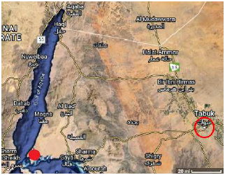
Once one knows that Kadesh-barnea is located at Tabuk, the Dead Sea no longer has any relevance to the translation of these verses. The Dead Sea is situated far to the north of Tabuk (Figure 1). Since it is the southern border of Israel which God is specifying, and since Israel included Tabuk/Kadesh-barnea, the Dead Sea is clearly not the sea being referenced.
Once the geographical context of these verses has shifted from the Negev to Tabuk, the "Salt Sea" mentioned in these verses shifts from the Dead Sea to the Gulf of Aqaba (Figure 3). I suggest that "the end of the Salt Sea" may not be the correct translation in this instance. The original literal Hebrew reads "the salt of sea to the end." I suggest that the proper translation may be "the End Salt Sea" and that the End Salt Sea was what we today call the Gulf of Aqaba.
 |
The Septuagint endorses this translation. In 1 Kings 9:26, in connection with Solomon's port at Ezion-geber, the Septuagint designates the Gulf of Aqaba as "the last sea." David Ben-Gad HaCohen of Hebrew University comments on this as follows:[2]
This name fits with one set of names the Bible uses for certain other seas: the Mediterranean Sea is called … "The Sea in the Back (or West)" and the Dead Sea … "The Sea in the Front (or East)" (see, e.g., Joel 2:20, Zech 14:8). The Gulf of Aqaba would have been a faraway sea for the writers of Kings, hence the name "Sea at the End" or "Furthermost Sea."
With the Gulf of Aqaba as the sea being referenced, natural geography then presents its southern extremity as the proper starting point for the delineation of Israel's southern border given by God through Moses in these verses.
The coastline of the Red Sea runs nearly due east from the south end of the Gulf of Aqaba (Figure 3). God, evidently, is placing the southern border along this coastline when He says, "your southern border shall extend from the [Gulf of Aqaba] eastward."
Eventually this coastline begins to bend toward the south. This is as it should be, because God next says, just before mentioning the ascent of Akrabbim, "Then your border shall turn direction from the south …," not from the east.
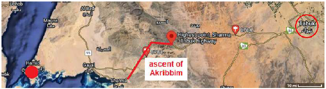
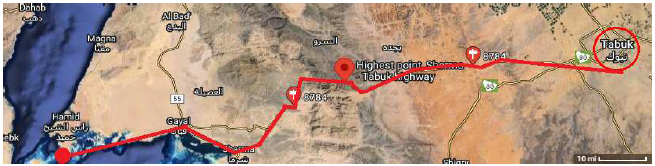
At this point, rather than continuing southward, one should look for a road turning inland, going up over the mountains toward Tabuk: "Then your border shall turn direction from the south to the ascent of Akrabbim." This road is identified as the modern Route 8784 on Google Maps (Figure 4). It runs between Sharma on the coast of the Red Sea up over the mountains to Tabuk. This identifies the ascent of Akrabbim as the ascent of this road up into the mountains.
 |
This identification of the ascent of Akrabbim is further affirmed by an additional geographical detail relevant to this boundary given in Joshua 15:1–3:
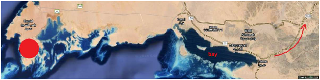
Now the lot for the tribe of the sons of Judah according to their families reached the border of Edom, southward to the wilderness of Zin at the extreme south. And their south border was from the [Gulf of Aqaba], from the bay that turns to the south. Then it proceeded southward to the ascent of Akrabbim and continued to Zin, then went up by the south of Kadesh-barnea …This description of the southern boundary specifies that it included a "bay that turns to the south." Google Maps reveals a properly situated bay (Figure 5). Notice how the road turns due south as one rounds the east end of this bay. This precisely fits the primary directive found in Numbers,"Then your border shall turn direction from the south to the ascent of Akrabbim …"
 |
In addition, this "ascent of Akrabbim" road—Route 8784—takes one naturally to Tabuk/Kadesh-barnea. This naturally suits the biblical description of this portion of the southern boundary (Figure 6): "your southern border shall extend from the end of the [Gulf of Aqaba] eastward. Then your border shall turn direction from the south to the ascent of Akrabbim, and continue to Zin [the local wilderness in which Kadesh-barnea was situated], and its termination shall be to the south of Kadesh-barnea …"
 |
Though identifying the site of ancient Kadesh-barnea with modern Tabuk departs radically from the traditional site of Kadesh-barnea (Figure 1), this identification has now been found to allow the mystery of the location of the ascent of Akrabbim to be solved, affirming its correctness. ◇
The Biblical Chronologist is written and edited by Gerald E. Aardsma, a Ph.D. scientist (nuclear physics) with special background in radioisotopic dating methods such as radiocarbon. The Biblical Chronologist has a fourfold purpose:
The Biblical Chronologist (ISSN 1081-762X) is published by: Aardsma Research & Publishing Copyright © 2024 by Aardsma Research & Publishing. Scripture quotations taken from the (NASB®) New American Standard Bible®, Copyright© 1960, 1971, 1977, 1995 by The Lockman Foundation. Used by permission. All rights reserved. www.Lockman.org } |