
| |
| Volume 14, Number 13 | August 8, 2024 |
My objective with the route of the Exodus series has now largely been realized—the basic route from Egypt to Canaan is now known. Of forty-one Exodus encampments listed by Moses in Numbers 33:1–49, seventeen have now been located on the map, and these seventeen are sufficient to show the basic route. The problem of properly locating many of the remaining encampments seems likely to require deliberate field archaeology to solve, working from the now known basic route. I have no training as a field archaeologist, and other Bible/science urgencies are demanding my attention, but a few things related to this topic need to be addressed before moving on. One of these, tackled this issue, is the biblical geography of the Israelites' Transjordan Eviction/Conquest of the Amorites.
The Israelites of the Exodus made a military excursion northward on the east side of the Jordan River to dispossess the Amorites living there, shortly before crossing the Jordan at Jericho to dispossess the inhabitants of Canaan. The purpose this issue is to begin to establish the correct geography of this portion of the biblical historical narrative of the Exodus.
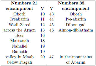
I have previously discussed how the historical record of events found in Numbers 21 parallels the list of encampments found in Numbers 33.[1] When the encampments in these parallel passages are tabulated, four encampments appear to be missing from the Numbers 33 list (Table 1). These four encampments—Beer, Mattanah, Nahaliel, and Bamoth—are in the right position in the sequence to be encampments of the Eviction/Conquest of the Amorites. They appear to be deliberately excluded from the Numbers 33 list, which is devoted to "the journeys of the sons of Israel, by which they came out from the land of Egypt by their armies," (verse 1), not to the journeys of the Eviction/Conquest.
 |
Two issues ago, it was learned that the Israelites' entrance into the Promised Land began with the crossing of the brook Zered.[2] This crossing moved the nation of Israel from territory belonging to the kingdom of Moab, on the south side of the Zered, to territory belonging to the kingdom of Sihon, on its north side, instigating war with Sihon.
The inhabitants of the kingdom of Moab (and also the kingdom of Ammon) traced their ancestry back to Lot, the nephew of Abraham. As such, they were distant relatives of the Israelites. God forbade the Israelites to instigate war with these descendants of Abraham, plainly stating that He would give them none of their land.
In contrast, the kingdom of Sihon and the neighboring kingdom of Og were of Amorite descent. The Amorites were already long-resident in Transjordan by the time Abraham arrived in Canaan, some 500 years previous to the Exodus. God had promised to Abraham that his descendants would one day possess the land of the Amorites (Genesis 15:18–21). Now, near the end of their long journey from Egypt to Canaan, God commanded the Israelites of the Exodus to cross the Zered brook both to make their way to the plains of Moab opposite Jericho, from whence the Conquest of Canaan was to be launched, and to instigate war with Sihon to take his land. God was fulfilling His ancient promise to Abraham in all of this.
Numbers 21:24 informs us:
Then Israel struck him [Sihon] with the edge of the sword, and took possession of his land from the Arnon to the Jabbok, as far as the sons of Ammon; for the border of the sons of Ammon was Jazer.
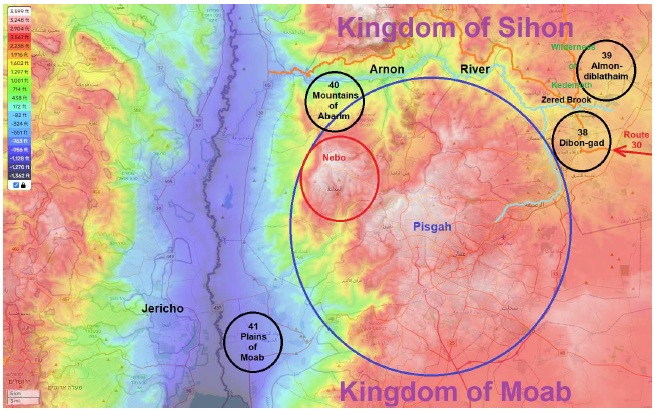
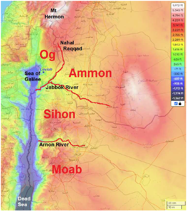
The river Arnon formed the northern border of the kingdom of Moab and the southern border of the kingdom of Sihon (Figure 1) as previously discussed.[3] Evidently, the kingdom of Sihon was bordered on the north by another river, the Jabbok.
 |
Deuteronomy 3:16–17 paints this same picture:
And to the Reubenites and to the Gadites, I gave from Gilead even as far as the valley of Arnon, the middle of the valley as a border and as far as the river Jabbok, the border of the sons of Ammon…
The next major river to the north of the Arnon is today called the Yarmuk. I propose that the Yarmuk is the biblical Jabbok (Figure 2).
 |
This proposal seems immediately supported by the phonetic similarity between these two names. The vocalization of m and b are closely related in these two names, of course, and the pronunciation of the Hebrew for Jabbok begins with Y in place of J.
Hebrew has no J sound like the one in English. Whenever we see a J in the English translation of a Hebrew name (Jehovah, Jerusalem, Jesse, Jonah, Jordan, Joseph, Joshua, Judah, etc.), we should understand that the corresponding Hebrew name has a Y sound in the same position.[4]
After conquering the kingdom of Sihon, the Israelites went on to conquer the kingdom of Og.
The biblical historical narrative informs us that Og's kingdom was located to the north of Sihon's kingdom. Moses, speaking to the Israelite nation, said:
"Thus we took the land at that time from the hand of the two kings of the Amorites who were beyond the Jordan, from the valley of Arnon to Mount Hermon…" (Deuteronomy 3:8)Since Sihon's kingdom was bordered on the south by the Arnon and on the north by the Jabbok, this verse informs us that Og's kingdom must have occupied land between the Jabbok and Mount Hermon (Figure 2).
This region is known as the Golan today.
The term Golan applies to the part of Transjordan that extends from the Yarmuk River northward to Mount Hermon and is bordered on the west by the Jordan Rift Valley and on the east by Nahal Raqqad.[5]Nahal Raqqad is the tributary of the Jabbok flowing down from the north which I have traced in red in Figure 2.
That Ammon, which was the main neighbor of Sihon north of the Jabbok according to the verses quoted previously, did not occupy the north side of the westernmost roughly 10 miles of the Jabbok is made clear by the archaeology of the region. I have previously reported on the Leviah Enclosure, a city located on a promontory overlooking the eastern shoreline of the Sea of Galilee (Figure 2), conquered by the Israelites at the time of the Eviction/Conquest.[6] Leviah fits the biblical description of the cities of Og. Moses described these cities as follows:
A modern archaeologist, Moshe Kochavi, provides the following description resulting from archaeological excavation at the Leviah Enclosure:
"All these were cities fortified with high walls, gates and bars, besides a great many unwalled towns. And we utterly destroyed them…" (Deuteronomy 3:5–6a)
The abundance of whole vessels found on the floors of the houses indicates that the last settlement ended in sudden destruction. …Excavations along the line of the outer wall (area C) exposed a wide gate between towers; the bases of the latter, as much as 16 m [52 feet] thick, were preserved to a height of more than 5 m [16 feet]. … The interior of the gateway was found full of fallen bricks, charred wooden beams, and dozens of rounded pebbles, probably used as projectiles. A solid wall (3 m [10 feet] thick) was built across the width of the gate, undoubtedly an attempt by the defenders to block the entrance to the town during the last siege. Reexamination of the pile of stones that crossed the center of the site (area A) revealed that the town had another, inner wall, at least 4 m [13 feet] thick, built of carefully laid stone courses. The gate in the inner wall was also found deliberately blocked up for its entire width.[7]
Leviah, which overlooks the east bank of the Sea of Galilee, was clearly a city of Og. Thus the strip of land north of the Jabbok which was bordered on the east by Nahal Raqqad was occupied by Amorites, not Ammonites.
The biblical historical narrative seems to equate Bashan with the territory of Og.
"So the Lord our God delivered Og also, king of Bashan, with all his people into our hand, and we smote them until no survivor was left. And we captured all his cities at that time; there was not a city which we did not take from them: sixty cities, all the region of Argob, the kingdom of Og in Bashan.
It thus appears that the modern Golan corresponds to the biblical Bashan.
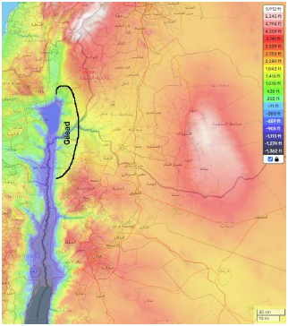
Gilead, I suggest, should be identified with the mostly greenish-shaded Transjordan strip in Figure 2 from north of the Sea of Galilee to roughly an equal distance south of the river Jabbok (Figure 3). This assignment follows from the biblical record of the split apportionment of Gilead between tribes—the river Jabbok flowing through the middle of it providing an explanation of why it was apportioned this way.
"From Aroer, which is by the valley of Arnon, and half the hill country of Gilead and its cities, I gave to the Reubenites and to the Gadites. And the rest of Gilead, and all Bashan, the kingdom of Og, I gave to the half-tribe of Manasseh…" (Deuteronomy 3:12b–13a)
 |
This identification may also find some support in the phonetic similarity between the modern Galilee and the ancient Gilead.
All of these place assignments need to be checked against data from field archaeology, of course. Amorite culture should be easily distinguishable archaeologically from Ammonite and Moabite cultures, allowing complete boundaries for these separate ethnicities ultimately to be extended beyond those afforded by the rivers.
And, ultimately, we may expect the many cities mentioned in the biblical narrative of the Amorite Eviction/Conquest to be properly identified with archaeological remains, allowing them to be accurately located on a modern map as well. ◇
The Biblical Chronologist (ISSN 1081-762X) is written and edited by Gerald E. Aardsma, Ph.D. (nuclear physics) with special background in radioisotopic dating methods such as radiocarbon, and is published by: Aardsma Research & Publishing Copyright © 2024 by Aardsma Research & Publishing. Unless otherwise indicated, scripture quotations are taken from the (NASB®) New American Standard Bible®, Copyright© 1960, 1971, 1977, 1995 by The Lockman Foundation. Used by permission. All rights reserved. www.Lockman.org } |
^ Gerald E. Aardsma, "The Route of the Exodus, Part XII: The Locations of the Mountains of Abarim, the Mountains of Abarim Encampment, Mount Pisgah, Mount Nebo, and the Arnon River," The Biblical Chronologist 14.10 (June 18, 2024): 2–3. www.BiblicalChronologist.org.
^ Gerald E. Aardsma, "The Route of the Exodus, Part XIII: The Locations of the Dibon-gad and Almon-diblathaim Encampments, the Brook Zered, and the Wilderness of Kedemoth," The Biblical Chronologist 14.11 (July 9, 2024): 1–5. www.BiblicalChronologist.org.
^ Gerald E. Aardsma, "The Route of the Exodus, Part XIII: The Locations of the Dibon-gad and Almon-diblathaim Encampments, the Brook Zered, and the Wilderness of Kedemoth," The Biblical Chronologist 14.11 (July 9, 2024): 1–5. www.BiblicalChronologist.org.
^ Tom Godfrey, Personal communication. August 1, 2024.
^ Zvi Uri Ma'Oz, "Golan," The New Encyclopedia of Archaeological Excavations in the Holy Land, vol. 2 (New York: Simon & Schuster, 1993), 525.
^ Gerald E. Aardsma, "Leviah—City of Og," The Biblical Chronologist 1.5 (September/October 1995): 1–7. www.BiblicalChronologist.org.
^ Moshe Kochavi, "Leviah Enclosure," The New Encyclopedia of Archaeological Excavations in the Holy Land, vol. 3, ed. Ephraim Stern (New York: Simon & Schuster, 1993), 916.