
| |
| Volume 14, Number 11 | July 9, 2024 |
Last issue, the location of the Mountains of Abarim encampment was established.[1] In the process, the true river Arnon was identified. These discoveries provide the foundation needed to locate the two encampments preceding the Mountains of Abarim encampment. These are encampments numbers 38, Dibon-gad, and 39, Almon-diblathaim, from the official list of encampments found in Numbers 33:1–49.
And they journeyed from Iyim, and camped at Dibon-gad. And they journeyed from Dibon-gad, and camped at Almon-diblathaim. And they journeyed from Almon-diblathaim, and camped in the mountains of Abarim, before Nebo. (Numbers 33:44–47)
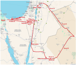
We have previously seen that the Israelites were approaching the Promised Land along the road which today is designated as Route 30, their ultimate destination being the plains of Moab across the Jordan River from Jericho (Figure 1).
 |
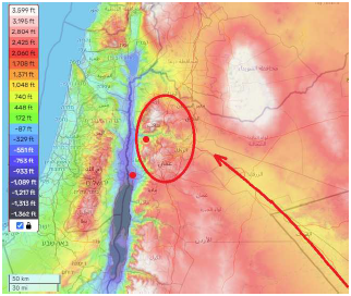 |
They would cross the mountains of Abarim via the pass through the mountains provided by the valley of the Arnon river to get to the plains of Moab (Figure 2).
The Numbers 33 listing is intended as a list, not as historical narrative. The historical narrative of this final leg of the journey from Egypt to Canaan is found in two places, one in Numbers and the other in Deuteronomy.
In Numbers, the historical narrative of current interest relates:
And they journeyed from Oboth, and camped at Iyeabarim, in the wilderness which is opposite Moab, to the east. From there they set out and camped in Wadi Zered. From there they journeyed and camped on the other side of the Arnon, which is in the wilderness that comes out of the border of the Amorites, for the Arnon is the border of Moab, between Moab and the Amorites. (Numbers 21:11–13)This parallels the Numbers 33 listing.
And they journeyed from Oboth, and camped at Iye-abarim, at the border of Moab. And they journeyed from Iyim, and camped at Dibon-gad. And they journeyed from Dibon-gad, and camped at Almon-diblathaim. And they journeyed from Almon-diblathaim, and camped in the mountains of Abarim, before Nebo. (Numbers 33:44–47)Iye-abarim is designated in three different ways in these two passages—Iye-abarim, Iyeabarim, and Iyim—but all of these designations obviously refer to the same place. The parallelism shows that Dibon-gad is the name of the encampment which was in the Wadi Zered, and Almon-diblathaim is the name of the encampment which was in the wilderness on the other side of the Arnon. The second historical narrative of this final leg of the journey is found in Deuteronomy 2:9–37. In this passage, Moses is recounting to the Israelite nation, shortly before his death, the end of the journey to the Promised Land. It is the most informative historical narrative for the purpose of locating the Dibon-gad and Almon-diblathaim encampments. Here are the most pertinent excerpts for the present purpose.
"Then the Lord said to me, … 'Now arise and cross over the brook Zered yourselves.' So we crossed over the brook Zered. Now the time that it took for us to come from Kadesh-barnea, until we crossed over the brook Zered, was thirty-eight years; until all the generation of the men of war perished from within the camp, as the Lord had sworn to them. …
So it came about when all the men of war had finally perished from among the people, that the Lord spoke to me, saying '… Arise, set out. and pass through the valley of the Arnon. Look! I have given Sihon the Amorite, king of Heshbon, and his land into your hand; begin to take possession and contend with him in battle. …'
So I sent messengers from the wilderness of Kedemoth to Sihon king of Heshbon with words of peace, saying, 'Let me pass through your land, I will travel only on the highway; I will not turn aside to the right or to the left.' … "
These passages have always seemed somewhat obscure. For instance, what is the meaning of the phrase "cross over the brook Zered yourselves?" Why the "yourselves?" Why not just, "cross over the brook Zered?" And what is the meaning of the phrase "the wilderness that comes out of the border of the Amorites?" How can a wilderness come out of a border? And what is the big deal about having crossed the brook Zered and the time it took from Kadesh-barnea to do so? What was so special about the brook Zered? Why no mention of the time it took to get to any other landmark along the way? And why the conflict with Sihon at this point in the journey? But all obscurity vanishes as soon as these passages are read in the context of the biblical geography proposed in Figure 3.
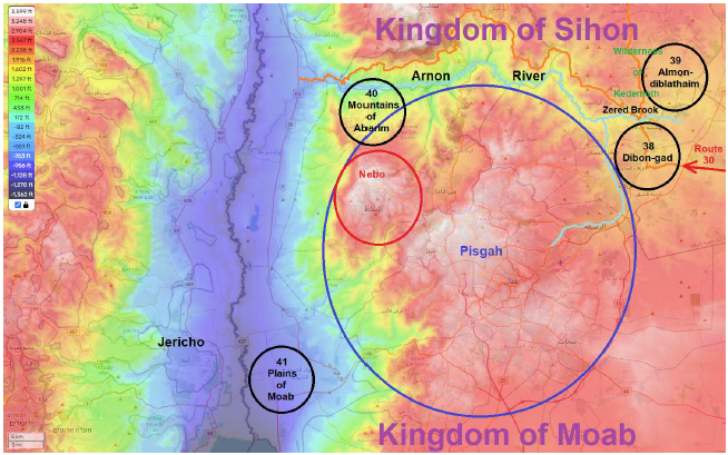 |
The conflict with Sihon finds immediate explanation as follows.
We have seen repeatedly in this series that modern roads seem to follow ancient roads. This is hardly surprising. Ancient roads will lie along the most easily traveled path from one location to another and there will generally not be reason to choose a less easily traveled path in modern times. It is therefore generally safe to assume that modern roads will reflect ancient routes. This observation is quite important in the present context.
Knowing the true location of the Arnon river allows us to see, on a modern map (Figure 4), that the only road exiting from the Arnon valley into the plains of Moab is on the north side of the river. This means that, to get to where they were going via the Arnon pass, using available roads, the Israelites had to cross to the north side of the Arnon.
 |
Now, the biblical historical narrative informs us, in the Numbers 21 passage quoted previously, that the Arnon was the boundary between Moab and the Amorites. The south side of the Arnon was territory of Moab. The north side was territory of the Amorite king, Sihon. Thus, to get to the plains of Moab via the valley of the Arnon, the Israelites had no choice but to travel through Sihon's territory. Hence the conflict with Sihon at this point in the journey.
The significance of the brook Zered also finds immediate explanation. But first, we need to locate the Zered brook on the map. This is not hard to do based on the physical geography we already know and what we are told by the biblical historical narrative.
Focusing again on the big picture shown in Figure 3, at this point in the narrative, imagine that the Israelites have come nearly to the end of modern Route 30, say at the tip of the red arrow I have drawn in the figure. Lying immediately before them, the topographical map shows, is the confluence of two tributaries of the Arnon. Straight ahead is a tributary coming down from Pisgah. On the right is a tributary flowing along the valley floor. They make camp on the valley floor—"in Wadi Zered"—up against this right-hand tributary. To get to where they are ultimately headed, they will need to cross this tributary. Thus the biblical historical narrative and the physical geography demand that this tributary must be the brook Zered.
Why the brook Zered was such a big deal immediately clarifies. It is an extension of the Arnon river. It represents part of the boundary between Moab and the Amorites. The north side of this brook is Amorite territory.
Now, the Amorites had been specifically identified by God in a promise made to Abraham some 500 years previously.
On that day the Lord made a covenant with Abram, saying, "To your descendants I have given this land, From the river of Egypt as far as the great river, the river Euphrates: the Kenite and the Kenizzite and the Kadmonite and the Hittite and the Perizzite and the Rephaim and the Amorite and the Girgashite and the Jebusite." (Genesis 15:18–21)This means that the land north of the Zered brook was part of the land which God had promised to give to Abraham's descendants. The land the Israelites were camped on at this point in the narrative, the Dibon-gad encampment, south of the brook Zered, belonged to the Moabites. God had given this land to the Moabites, descendants of Abraham's nephew, Lot. The Israelites were repeatedly warned by God not to try to take any of the Moabites' land. In contrast, the land north of the brook Zered was Amorite land, and God was telling the Israelites, at this point in their journey, to take this land.
In short, the crossing of the brook Zered would represent the first entrance into the Promised Land. That's why Moses emphasizes that the brook Zered was not crossed until all the generation of the men of war who had rebelled at Kadesh-barnea had died. God had sentenced that generation of men never to enter the Promised Land.
Surely all the men who have seen My glory and My signs, which I performed in Egypt and in the wilderness, yet have put me to the test these ten times and have not listened to my voice, shall by no means see the land which I swore to their fathers, nor shall any of those who spurned Me see it. (Numbers 14:22–23)Crossing the brook Zered would take the surviving Israelites into "the land which I swore to their fathers"—into the Promised Land. It would inaugurate the Eviction/Conquest. It would begin to fulfill 500 year-old prophecy. That's why this crossing was such a big deal.
The "yourselves" of the phrase "cross over the brook Zered yourselves" also finds immediate explanation. The idea behind "yourselves" in this context becomes "of your own initiative, without asking permission."
God is here instigating war between Sihon and Israel. To cross the Zered into Sihon's land without first asking permission of Sihon was to trespass and intrude. The Israelites could not go very far into Sihon's territory without becoming the obvious aggressors. To become the obvious aggressors would likely bring other kingdoms, such as the neighboring Amorite kingdom of Og, immediately into the conflict, combining forces with Sihon to stop the Israelites. It was better military strategy at this stage to let Sihon be the aggressor. This was accomplished by merely crossing the Zered and camping on the other side. It is one thing if someone knocks on your door and asks you for a drink of water. It is quite a different thing when someone enters your home without knocking and asks you for a drink of water. Moses entered Sihon's territory without knocking and then asked permission to use his roads. Sihon responded by calling out his army against the Israelites, to drive them from his land.
Finally, the biblical historical narrative tells us that Moses sent his request to use Sihon's roads "from the wilderness of Kedemoth." Thus, this must be the name of the wilderness to the north of the Zered where they were then camped. Looking at the map of Figure 3, the biblical reference to this wilderness as "the wilderness that comes out of the border of the Amorites" no longer seems at all obscure. We would likely refer to it as "the wilderness stretching northward from Zered Brook," which means exactly the same thing.
The ability of the biblical geography shown in Figure 3 to make simple sense of an otherwise somewhat obscure biblical historical narrative argues forcefully that it is correct.
Before closing this issue, it seems necessary to point out that the eradication of the Amorite kingdoms of Sihon and Og—men, women, and children—was not an arbitrary act of God. It was a deliberate judgment of God. Evidently, there comes a point where a nation sinks into such evil and depravity that the world is simply better off without that nation.
When God promised Abraham that his descendants would possess the land, He also foretold their enslavement in Egypt, their deliverance, and the reason these things would not transpire for hundreds of years.
And God said to Abram, "Know for certain that your descendants will be strangers in a land that is not theirs, where they will be enslaved and oppressed four hundred years. But I will judge the nation whom they will serve; and afterward they will come out with many possessions. And as for you, you shall go to your fathers in peace; you shall be buried at a good old age. Then in the fourth generation they shall return here, for the iniquity of the Amorite is not yet complete." (Genesis 15:13–16)
By the time the Israelites had encamped at Almon-diblathaim, the iniquity—the wickedness—of the Amorites had evidently come to completion. Indeed, it seems that the iniquity of the Amorites must have passed completion forty years earlier when the Eviction/Conquest was supposed to have been launched. It appears that God's judgment was a generation overdue. In any event, God's judgment was now about to fall. Just as God had previously, in judgment, baited Pharaoh into the Reed Sea death trap,[2] so He now, in judgment, baited Sihon into war with Israel. In both instances, God's day of grace had ended, and His day of judgment had come. ◇
The Biblical Chronologist is written and edited by Gerald E. Aardsma, a Ph.D. scientist (nuclear physics) with special background in radioisotopic dating methods such as radiocarbon. The Biblical Chronologist has a fourfold purpose:
The Biblical Chronologist (ISSN 1081-762X) is published by: Aardsma Research & Publishing Copyright © 2024 by Aardsma Research & Publishing. Scripture quotations taken from the (NASB®) New American Standard Bible®, Copyright© 1960, 1971, 1977, 1995 by The Lockman Foundation. Used by permission. All rights reserved. www.Lockman.org } |
^ Gerald E. Aardsma, "The Route of the Exodus, Part XII: The Locations of the Mountains of Abarim, the Mountains of Abarim Encampment, Mount Pisgah, Mount Nebo, and the Arnon River," The Biblical Chronologist 14.10 (June 18, 2024): 1–8. www.BiblicalChronologist.org.
^ Gerald E. Aardsma, "Understanding the Red/Reed Sea Crossing," The Biblical Chronologist 13.6 (July 11, 2023): 1–8. www.BiblicalChronologist.org.