
| |
| Volume 14, Number 10 | June 18, 2024 |
Having, two issues ago,[1] located the Plains of Moab encampment and, most importantly, having at the same time identified the route the Israelites took from Kadesh-barnea to get to the Plains of Moab encampment, we are now in a position to locate the Mountains of Abarim encampment. This is the next-to-last encampment, number 40 of the official list found in Numbers 33:1–49.
And they journeyed from Almon-diblathaim, and camped in the mountains of Abarim, before Nebo. And they journeyed from the mountains of Abarim, and camped in the plains of Moab by the Jordan opposite Jericho. (Numbers 33:47–48)
The Mountains of Abarim encampment is located "in the mountains of Abarim." To locate this encampment, we need to locate these mountains.
Traditional locations cannot be relied on at this stage. As explained in the previous issue,[2] tradition has the final leg of the route of the Exodus seriously wrong. These mountains will necessarily be intimately associated with the actual route the Israelites took at this final stage of their journey. In the biblical narrative, these mountains are being treated as landmarks, just the way the reed sea was treated as a landmark in the case of the Reed Sea encampment.[3] If one is following the same road the Israelites were following on their way to Canaan, one will not be able to miss these mountains. If, on the other hand, one is confused—lost—and following some other road, such as the traditional road, one will misidentify these landmarks.
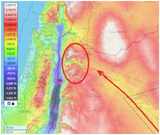
As it turns out, it is possible to identify these mountains with little ambiguity using a topographic map and the known route the Israelites were following with the intention of arriving ultimately in the plains of Moab (Figure 1). The clear implication is that the "mountains of Abarim" should be understood to be referring to two distinct massifs separated by a river valley.
 |
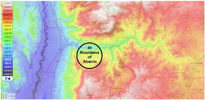
It is most unlikely that the whole nation of Israel would have climbed these mountains, carrying all their earthly possessions, to camp in them high in the sky. Evidently, "in the mountains of Abarim" does not mean that the Israelites camped high up in these mountains but rather that they camped in the river valley dividing these two massifs—the encampment setting was "in the mountains."
Where exactly, in this river valley, would they have camped?
Zooming in on the topographic map (Figure 2) reveals that there is only one spot big enough to accommodate the nation. This is where the valley widens as it is emerging from the mountains, just prior to joining with the plains of the River Jordan. Thus, this must be the site of the Mountains of Abarim encampment.
 |
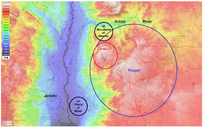
This identification is confirmed by the reference to "Nebo." We learn from the biblical historical record that Nebo was a peak of Mount Pisgah.
The Israelites temporarily diverted from their main route to Canaan to go north into the kingdoms of the Amorite kings Sihon and Og to conquer these kingdoms. We have previously seen that there was a similar military diversion to retaliate against the Canaanite king of Arad while they were camped at Mount Hor. Details of these military diversions and other noteworthy happenings along the journey to Canaan are recorded in Numbers 21, which provides an itinerary parallel to the one in Numbers 33. This parallel itinerary appears to refer to the Mountains of Abarim encampment when it mentions "the valley that is in the land of Moab."
And from the wilderness they continued to Mattanah, and from Mattanah to Nahaliel, and from Nahaliel to Bamoth, and from Bamoth to the valley that is in the land of Moab, at the top of Pisgah which overlooks the wasteland. (Numbers 21:18b–20)This translation (from the NASB, which is routinely used in this research newsletter) is confusing because it seems to place the valley at the top of Pisgah. Other versions present a different picture. For example, the NIV translates verse 20 this way:
and from Bamoth to the valley in Moab where the top of Pisgah overlooks the wasteland.As a second example, the ESV translates it this way:
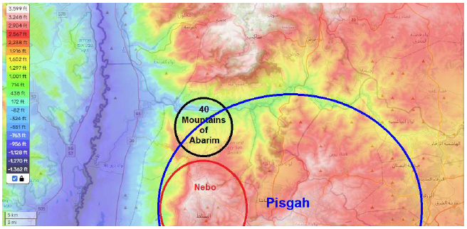
and from Bamoth to the valley lying in the region of Moab by the top of Pisgah that looks down on the desert.These other translations cause me to suggest that this verse is, in fact, completely parallel to the "and camped in the mountains of Abarim, before Nebo" of Numbers 33:47, quoted above. These parallel accounts can be unified if we understand Pisgah to be the name of the southern massif of the two massifs making up the mountains of Abarim, and Nebo to be the name of one of the peaks of the Pisgah massif, as shown in Figure 3. This unification results in the Mountains of Abarim encampment being situated "before Nebo" as Numbers 33:47 requires.
 |
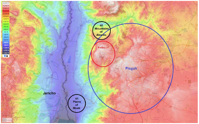
This overall understanding is corroborated by subsequent biblical historical references to Abarim, Nebo, and Pisgah (Figure 4) which occur in connection with instructions given to Moses while the Israelites resided at the Plains of Moab encampment. There God told him to climb Mount Nebo and view the land of Canaan. The following passages require not only that Mount Nebo must be in the mountains of Abarim and adjacent to the Mountains of Abarim encampment, but also that it must be in the land of Moab, that it must be a summit of Pisgah, that Pisgah must be opposite Jericho, and that the summit of Nebo must be high enough to enable Moses to see for many miles to the west, northwest, and southwest, while at the same time also providing a clear view of the plains of the Jordan near at hand.
 |
Then the Lord said to Moses, "Go up to this mountain of Abarim, and see the land which I have given to the sons of Israel." (Numbers 27:12)
And the Lord spoke to Moses that very same day, saying, "Go up to this mountain of the Abarim, Mount Nebo, which is in the land of Moab opposite Jericho, and look at the land of Canaan, which I am giving to the sons of Israel for a possession." (Deuteronomy 32:48–49)
Now Moses went up from the plains of Moab to Mount Nebo, to the top of Pisgah, which is opposite Jericho. And the Lord showed him all the land, Gilead as far as Dan, and all Naphtali and the land of Ephraim and Manasseh, and all the land of Judah as far as the Western Sea, and the Negev and the plain in the valley of Jericho, the city of the palm trees, as far as Zoar. (Deuteronomy 34:1–3)
According to the online topographic map used in the figures this issue, the summit of Nebo has an elevation slightly in excess of 3,630 feet. This appears to be the highest peak for the Pisgah massif, in literal agreement with the descriptive phrase, "to the top of Pisgah," in the just-quoted verse. This peak is several hundred feet higher than the mountains west of the Jordan River, providing an unimpeded view even to the "Western Sea" (i.e., the Mediterranean Sea) as the same verse requires.
A somewhat surprising result of these new place-name assignments is correction of the traditional location of the Arnon River. This item from biblical geography now needs to be added to its proper location on the map (Figure 5).
 |
On traditional and modern maps, the Arnon River is shown as the wadi which empties into the Dead Sea about halfway down its eastern shoreline. This assignment is now seen to be mistaken. This is most simply seen by the fact that the Arnon River was the border between Moab and the Amorite kingdom of Sihon:
for the Arnon is the border of Moab, between Moab and the Amorites. (Numbers 21:13b)This means that the territory of Moab stopped at the Arnon river.
Now Moab's southern neighbor was Edom. Thus the kingdom of Sihon was Moab's northern neighbor. This geographical ordering of kingdoms is seen, for example, in Moses' request of Sihon:
"Let me pass through your land, I will travel only on the highway; I will not turn aside to the right or to the left. You will sell me food for money so that I may eat, and give me water for money so that I may drink, only let me pass through on foot, just as the sons of Esau who live in Seir and the Moabites who live in Ar did for me, until I cross over the Jordan into the land which the Lord our God is giving to us." (Deuteronomy 2:27–29)
If the Arnon emptied into the Dead Sea halfway along its eastern shoreline, then the plains of the Jordan River north of the Dead Sea, opposite Jericho, should have been called the "plains of Sihon." But we have seen above that the text explicitly calls these plains "the plains of Moab." This implies that the land of Moab extended north of the Dead Sea. The border between Moab and the kingdom of Sihon—the Arnon River—must, therefore, have been north of the Dead Sea, not in the middle of it.
The preceding sections of this present article strengthen this argument by their proposed locations for Nebo, Pisgah, and the Mountains of Abarim encampment. The biblical account specifies that all of these places were in the land of Moab, south of this river.
Thus, this river, not the river to the south flowing into the middle of the Dead Sea, must be the Arnon River.
This surprising conclusion is further strengthened as follows.
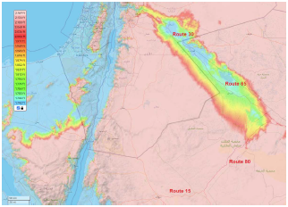
We saw last issue that the road the Israelites were on, as they approached Canaan from the east, followed a long valley in a northwesterly direction (Figure 6). This valley terminates in a riverbed which flows westward through the mountains of Abarim to join the Jordan River. The valley of this riverbed forms a natural pass through the mountains. If one is destined for the plains of Moab from the western egress of this valley, as the Israelites were, then this pass, modern topographic maps reveal, is the best way to get there.
 |
It is precisely at this stage in the journey—the Israelites about to emerge from the long valley, with the landmark mountains of Abarim before them—that the biblical history records God commanding Moses:
"Arise, set out, and pass through the valley of Arnon." (Deuteronomy 2:24a)This "pass through the valley of Arnon" does not appear to be instruction merely to cross the Arnon. They had previously crossed the Zered at God's command, and the language used there was quite different:
"Now arise and cross over the brook Zered yourselves." (Deuteronomy 2:13a)Thus, "pass through the valley of Arnon" appears to be an instruction to use the mountain pass afforded by the valley of the Arnon River to cross the mountains of Abarim to arrive ultimately at their intended destination, the plains of Moab, from which the Eviction/Conquest of Canaan was to be launched. The location of the Mountains of Abarim encampment (Figure 5) shows that this is indeed what they did.
We may safely conclude that the true Arnon River is the river to the north of the Dead Sea, specifically, the one which bisects the mountains of Abarim. On Google Maps, this river is identified as the Zarqa River. On traditional maps of biblical geography, it is mistakenly identified as the Jabbok River.
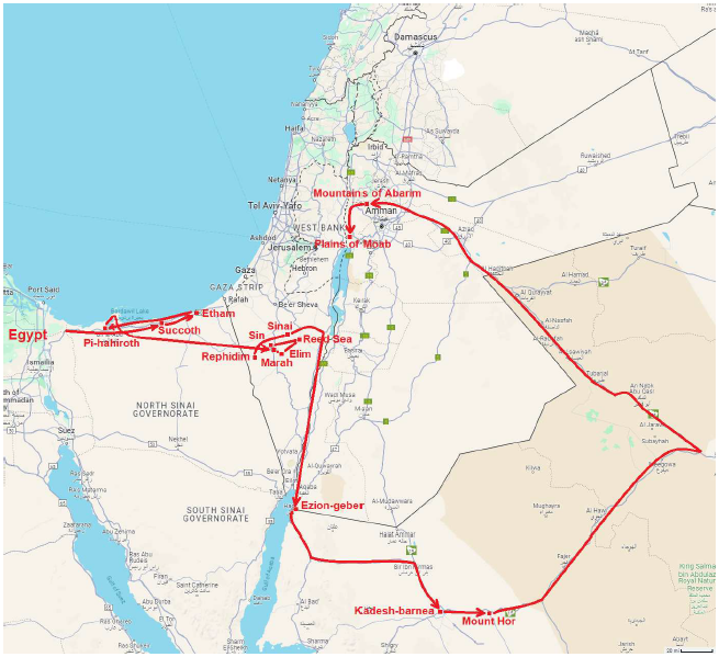
Ignoring the military diversion to the north, as was also done with the military diversion to Arad while the Israelites were camped at Mount Hor, it is now possible to draw the end of the route of the Exodus which was left off the map two issues ago. The result is shown in Figure 7.
 |
The traditional biblical geography of the Holy Land was worked out by scholars several generations ago. They got it very badly wrong. They had their chronology of the Exodus foreshortened by a thousand years, causing extreme historical disorientation at the outset—even as continues to be the case with establishment scholarship today. If you have ever had the experience of being lost, you know how confusing everything becomes. Old-time scholars were lost the moment they took the Israelites south from Egypt down to the traditional "Mount Sinai." From there, all was compounded confusion and disorientation.
But a new day has come, a cause of rejoicing for all who long to understand the truth regarding this most ancient history. ◇
The Biblical Chronologist is written and edited by Gerald E. Aardsma, a Ph.D. scientist (nuclear physics) with special background in radioisotopic dating methods such as radiocarbon. The Biblical Chronologist has a fourfold purpose:
The Biblical Chronologist (ISSN 1081-762X) is published by: Aardsma Research & Publishing Copyright © 2024 by Aardsma Research & Publishing. Scripture quotations taken from the (NASB®) New American Standard Bible®, Copyright© 1960, 1971, 1977, 1995 by The Lockman Foundation. Used by permission. All rights reserved. www.Lockman.org } |
^ Gerald E. Aardsma, "The Route of the Exodus, Part XI: The Location of the Plains of Moab Encampment (and the Path Taken to Get There)," The Biblical Chronologist 14.8 (May 28, 2024): 1–6. www.BiblicalChronologist.org.
^ Gerald E. Aardsma, "The Location of the Final 'Red Sea' of the Exodus," The Biblical Chronologist 14.9 (June 11, 2024): 1–5. www.BiblicalChronologist.org.
^ Gerald E. Aardsma, "The Route of the Exodus, Part X: The Location of the 'Red Sea' Encampment (and the Meaning of Yam Suph)," The Biblical Chronologist 14.4 (February 13, 2024): 1–5. www.BiblicalChronologist.org.