
| |
| Volume 5, Number 3 | May/June 1999 |
Miles of stone walls are found in Ireland—a common enough observation perhaps, but the stone walls I am referring to are far from common. They are so unusual, in fact, that a $3 million tourist center has been built to show them off.
North Mayo, Ireland, where the walls are found, is bog country. The entire countryside is blanketed by bog-peat, more than twelve feet thick in places. The stone walls are found under the bog. They are built on the mineral soil that underlies the blanket peat.
The walls enclose fields—some 4,500 acres of fields. They're called "Céide Fields" (pronounced kay'jeh) today.
There can be no doubt about the original purpose of these fields. They were obviously used for agriculture—ridge and furrow plow marks can still be found in their mineral soil in some places today when the overlying peat has been cleared away.
These walled fields obviously went out of service a long time ago. Pine tree stumps are found today in growth position within the peat overlying them. The stumps have been preserved by the "pickling juice" of the bog in which they grew and which grew around them. In some cases the stumps are found in growth position immediately above a stone wall. Some of these stumps reveal more than 100 growth rings. Thus, simple dendrochronological considerations—in particular, the number of tree-rings found in a given stump—show that the stone walls which lie under the stumps must have gone out of service at least a century ago.
But stratigraphical considerations suggest that a single century is a serious underestimate of the age of these walls. The picture which emerges from the thick bog-peat containing preserved pine stumps within it is that this countryside went from 1. agricultural fields to 2. bog with pine forest to 3. just plain bog—as it is found today. And all of this change must have taken many centuries, at least.
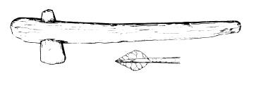
But archaeological investigation suggests that these walls are older even than many centuries. It reveals that they go back to a time, labeled the Irish Neolithic by the archaeologists, when the farmers who worked the land lacked the advantage of metals—they made their tools entirely of chipped stone, bone, and wood. Axeheads fashioned from igneous rock have been found in association with these stone walls, and flint arrowheads (Figure 1), and flint scrapers, but never any metals.
 |
And these farmers built massive tombs of huge stones—megalithic tombs, they're called—in which to dispose of their dead, remnants of which still dot the Irish countryside today. Such artifacts reach back into the distant prehistory of Ireland. Archaeology suggests that the age of these walls should be measured, not in centuries, but rather in millennia.
Many fascinating questions arise in connection with these ancient walls and tombs. Who were the people who built them? Where had they come from? How did they live?
But there is one mystery in connection with these walls which overshadows all others. What happened to the people who built these stone walls and these megalithic tombs?
Like the streets of Pompeii beneath their blanket of ash, the ancient agricultural landscape of Céide Fields lies preserved beneath a blanket of peat. But, unlike Pompeii—the fossilized forms of whose inhabitants can still be recovered from its blanket of ash today—the inhabitants of Céide Fields are entirely missing. Where did they disappear to? How did they come to leave their busy fields and beloved cemeteries—their homeland—to the creeping depredations of desolate bog and silent pine forest?
Archaeologists have been probing these ancient fields, asking these same questions for some decades now. They talk about the "abandonment" of Céide Fields, and speculate on what prompted it. But though they have wrestled skillfully with this ancient mystery, they are still quite a long ways from its correct solution.
Some have suggested that the climate may have changed, forcing the occupants to leave. Maybe it just got too wet, encouraging rapid bog growth and making the land just too difficult to farm.
Others have supposed that loss of soil fertility was the culprit. They point out that the clearing of the original forests for agricultural purposes would have exposed the soil directly to the abundant rainfall in that region. Perhaps this led to a leaching away of soil nutrients.
Or maybe the farmers allowed their cattle to overgraze the land, robbing it of grass cover and inviting the formation of peat from mosses, and hence turning pasture to bog.
These are all interesting suggestions. But they are also all wrong. I know they are wrong because the correct solution "falls out" of modern Biblical chronology. Yes, the correct answer is to be found, not by further probing of the ancient bog of North Mayo, Ireland, but by probing the ancient pages of the Bible. The mystery of the disappearance of the ancient farmers of Céide Fields is there revealed in the most simple, plain terms possible. Céide Fields was not "abandoned". It was depopulated. It's inhabitants were swept away by Noah's Flood.
Over the past several years we have, in The Biblical Chronologist, come to understand the nature of Noah's Flood. Foundational to this knowledge is the important fact of when this historical event took place. Modern results within the field of Biblical chronology inform us that the Flood happened 3520±21 B.C.[1]
Working from this key fact we have found that the Flood was neither local nor global. We have found that the geographical extent of the Flood waters was hemispherical, covering the northern hemisphere of the globe. We have been able to infer a physical mechanism explaining how God brought the Flood about, involving displacement of the inner core of the earth.[2]
I have called the conception of the nature of the Flood which has emerged from our study of the Bible and the data of science over the past several years the "hemispherical Flood model". We have seen this scientific model of the Flood confirmed repeatedly by actual field data. We have seen it confirmed in the ice sheets of the polar regions.[3] We have seen it confirmed by the basic field data of zoogeography.[4] We have seen it confirmed by sedimentary data from Elk Lake, Minnesota.[5] And we have seen it confirmed by archaeological data from Israel.[6]
A simple, yet far-reaching prediction of this model is that human cultures were abruptly terminated approximately 3500 B.C. wherever the waters of the Flood reached sufficient depth. This includes most of the northern hemisphere.
This prediction means that, whenever the secular archaeologists have achieved sufficient detail in their archaeological reconstructions, and the secular chronologists have achieved sufficient precision in their chronologies [and this may take a few decades yet in many areas], an abrupt termination of human culture will be found to exist synchronously near 3500 B.C. in all local and regional archaeological chronologies over most of the northern hemisphere.
We have already seen an isolated instance of the success of this prediction in the archaeology of modern Israel. There we found that the Chalcolithic people of Palestine—artistic, accomplished in the casting of copper, a people widespread all through Palestine and surrounding regions—suddenly, within secular dating uncertainties of 3500 B.C., all "disappeared from the stage of human history"[7] never to be seen or heard from again.[8]
But is this possibly just a lucky (or, perhaps, unlucky) coincidence? Can the abrupt termination of an entire culture and the disappearance of its people from the stage of history be replicated in another geographical region far removed from Palestine? To answer this question I focused my research over the past few months on Céide Fields, Ireland.
The hemispherical Flood model predicts abrupt termination of human culture wherever the water of the Flood was deep enough, and it specifies that this termination will be found within secular dating uncertainties of 3520±21 B.C. To test this prediction in Ireland two questions must be answered: 1. Was the Flood deep enough in Ireland to terminate human civilization there?, and 2. Is an abrupt termination of human culture seen in the archaeology of ancient Ireland near 3500 B.C.?
Figure 2 shows the depth of the Flood versus time over North Mayo, Ireland, as specified by the hemispherical Flood model. This graph shows that the Flood achieved a depth of roughly two and a half miles over North Mayo, and that it maintained that depth for five months. This would clearly be disruptive of any human culture in North Mayo.
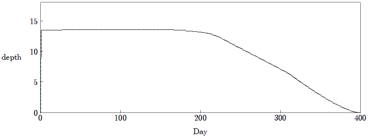 |
There are some uncertainties in this calculation at present, because of uncertainties which yet remain with some parameters of the hemispherical Flood model. For example, this calculation assumes the Kara Sea (63° E, 72° N) as impact center, as I have consistently assumed previously.[9] This is only my best guesstimate for the impact center at present; the true impact center may turn out to be located elsewhere in the high north.
But all such uncertainties have only a relatively minor impact on Figure 2. No matter what combination of values one chooses for parameters from the reasonable range of these uncertainties one gets the same result—an unequivocal prediction that any human culture in Ireland would certainly have been terminated by the Flood.[10]
One might think that the second question above (i.e., is an abrupt termination of human culture seen in the archaeology of ancient Ireland near 3500 B.C.?) would be easily answered by looking up the secular chronology of ancient Ireland in a textbook of some sort to see if there is a discontinuity of culture near 3500 B.C. Unfortunately, life is not so simple. The chronology of Ireland at the remote date of 3500 B.C., as with nearly all secular ancient chronologies today, is far from certain. Errors of half a millennium or more are not unthinkable at such a remote date.
It is important to understand that secular chronologies of the ancient past have generally evolved to their present forms. Their basic structures were often formulated long before radiocarbon came on the scene, which means they were often based more on the scholars' subjective impressions than on any solid physical measurements. These pre-scientific chronologies are often deeply entrenched and yield slowly to the (sometimes startling) readjustments called for by quantitative radiocarbon measurements.
In addition to this lack of quantitative precision inherited from the past, there is also a fairly ubiquitous inherited ideological bias in modern chronologies of the ancient world. The basic interpretive paradigm within which most scholars have worked over the past century has been evolution. This has predisposed scholars to favor gradualism, progress, and continuity in their interpretations of the past. They have been, and to a large measure remain, all but blind to the evidences of profound discontinuity their data display—the Flood itself being "Exhibit A" in this regard.
It is, for these reasons, necessary to adopt a deliberately empirical approach when evaluating whether an abrupt termination of human culture is seen in the archaeology of any culture near 3500 B.C. We do not wish to know what the scholars have been taught on the matter; we wish rather to learn what the field data have to say about it.
This leads to the following procedure. We first ask whether there is any field evidence of abrupt termination of human culture. We then apply physical dating techniques to this field evidence to see if the discontinuity dates to 3500 B.C.
I am far from an expert in the archaeology of Ireland—I am a chronologist, not an archaeologist. But the thousands of acres of peat-covered agricultural fields in North Mayo are rather obvious evidence of some sort of abrupt termination of human occupation in Ireland, even for the amateur. Field evidence of abrupt termination seems absent at other periods within the archaeological record of Ireland. It appears that the "abandonment" of Céide Fields is the only archaeological field evidence from Ireland presently known which is of interest to the present study.
We must now ask whether these agricultural fields went out of service within secular dating uncertainties of 3520±21 B.C., the date of Noah's Flood given us by modern Biblical chronology. To draw a cause and effect relationship between Noah's Flood and the "abandonment" of Céide Fields requires that these two events be synchronous in time.
It is one thing to realize that these fields must be thousands of years old, as I have pointed out in the introduction, and quite another to say exactly how many thousand years old. To obtain a reasonably precise date we will obviously need to make use of radiocarbon. Radiocarbon is, in fact, the only physical dating method applicable to this specific problem at present.
It is clear enough what we want to date. Stratigraphically speaking, we want to date the interface between the mineral soil of these ancient fields and the overlying peat. The peat obviously only began to cover the fields after the farmers had ceased to work them.
Unfortunately, one cannot date an interface with radiocarbon. Radiocarbon can only date organic (once living) samples. There are only two things which radiocarbon can date in the present case: 1. the peat lying above the mineral soil, and 2. the pine stumps preserved within the peat. Note that in either case we will not get the date of the interface (i.e., the date of the Flood). Rather, we will get the date when the plants represented by the peat and the stumps grew.
It might be thought that the peat is the preferred material for radiocarbon dating in the present case. Peat is made up of the dead remains of plants that once grew in a bog. By dating the lowest lying peat—that which is found right against the mineral soil—one might hope to get a date very close to the time when the fields went out of use and the bog began to grow over them.
Unfortunately, peat poses several dating difficulties. First, it is easily subject to contamination, making it a difficult material in general to get reliable absolute radiocarbon dates from. Efforts to increase the reliability of peat dates by improved methods of chemical pretreatment of peat samples to remove contaminants have been underway for decades and continue to the present time.[11]
Second, in our specific case it is impossible to guarantee that peat found immediately above the mineral soil actually grew there. The Flood obviously had potential to pick up older, pre-Flood peat, native to this whole region, and deposit it on these fields. Thus, the peat immediately above the mineral soil in any given sample column may actually be pre-Flood in origin.
Finally, it is equally impossible to guarantee that peat found immediately above the mineral soil actually began to grow there immediately following the Flood. Peat demands a high water table for its accumulation. It is doubtful that this condition was achieved everywhere synchronously over Céide Fields immediately following the Flood. It seems likely that low pockets would go over to bog more quickly than higher elevations, for example. The actual time lapse between the Flood and the initiation of peat growth at any specific location cannot be specified up front.
These difficulties do not eliminate peat from interest. They merely mean that deducing a precise date for when these fields went out of service is more complex than one might at first suppose. Certainly more is involved than just radiocarbon dating a single, randomly chosen peat sample from immediately above the mineral soil and seeing what you get.
The other possible sample material in the present case is wood from the tree stumps preserved within the peat. Wood has long been a preferred material for radiocarbon dating. It is not subject to the contamination problems which plague peat. Reliable, reproducible radiocarbon dates are routinely obtained from wood. Another advantage of the tree stumps over the peat in the present case is that they are found rooted in the bog in position of growth. This guarantees that they only began to grow after the fields had gone out of use.
The difficulty with the stumps is that we have no way of knowing how long after the fields had gone out of service they began to grow. This problem is even more serious with the stumps than it is with the peat because many of the trees are found to be growing above a considerable thickness of peat. Obviously, even many centuries could be involved. With nobody there to tend the fields any longer after the Flood, Céide Fields would be expected to overgrow first with weeds, then with brush, and eventually pine. The length of time required for pine to move into the region cannot be specified.
Dating precisely when these ancient fields went out of use is obviously not a trivial exercise. Neither the peat nor the pine stumps provide an ideal sample for addressing this question. But, though there are hurdles to be cleared, not all is lost by any means.
We are asking only, "Did these fields cease to be used 3520±21 B.C.?" Notice, first of all, that the answer to this question will be a definite "no" if these tree stumps date to any time prior to 3520±21 B.C. The trees which grew above the fields must date after the fields went out of service. If the stumps date before 3520±21 B.C. then we know that the fields went out of service before that date. In that case the Flood has nothing to do with the "abandonment" of Céide Fields. Thus, radiocarbon dates on these stumps, while not ideally suited to our purpose, obviously have something significant to say about the matter just the same.
But their potential contribution hardly stops there. In the event the stumps date after 3520±21 B.C., and thus do not falsify a Flood connection, they provide us with a means of determining the latest possible date the fields could have been in use. If this turns out to be 1000 or 2000 B.C., we will need to grant the possibility that the "abandonment" of Céide Fields may have taken place long after the Flood and may, therefore, have nothing to do with the Flood. We will need to search further in that case, asking, for example, what additional light peat dates might shed on the matter. But if these stumps date to just a few centuries following 3500 B.C. then we will know that Céide Fields was overgrown with pine trees within a few centuries of the Flood. In that case it will be difficult to avoid the conclusion that the "abandonment" of Céide Fields was a result of the Flood.
Figure 3 shows radiocarbon dates from forty pine stumps found preserved within the blanket peat of Céide Fields.[12] Each (often broken) vertical black bar indicates the interval(s) in which the true calendar date of the sample is most likely to lie (i.e., when the wood sample being dated most likely grew). Radiocarbon does not furnish a single date for a sample. Rather, it gives a probability distribution describing the relative probability the sample originates in a given time interval. The probability is roughly two-thirds that the true date of the sample falls somewhere in the black barred region(s).
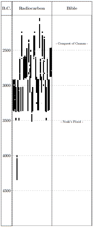 |
What is immediately striking about Figure 3 is that all but one of these stumps date after the Flood, and many date relatively soon after the Flood. (The one older, pre-Flood date, we may assume, reflects a tree which grew before Céide Fields was ever cleared. Its stump was preserved because it was already covered up by bog in some small hollow before the arrival of the pre-Flood Irish settlers.) A cause-and-effect relationship between the Flood and the incursion of these trees is hardly farfetched.
Figure 3 shows that trees were well established over Céide Fields by 3200 B.C. at the latest. This is consistent with the view that these fields ceased to be used because the region was depopulated by the Great Flood 3520±21 B.C. Figure 3 also shows an absence of dates in the centuries immediately prior to 3500 B.C. This is consistent with the view that these ancient fields were worked (and hence kept free of trees) for some centuries up until the time of the Flood. In summary, Figure 3 shows that by 3200 B.C. Céide Fields wore a veneer of blanket peat and pine trees over fields which had been cultivated for agricultural purposes a mere three centuries previously.
On the basis of these radiocarbon dates the original researchers, S. Caulfield et al., concluded:[13]
At the latest, blanket bog was widespread in North Mayo by 4500 BP [3265 B.C.]. Indeed, it is reasonable to suggest that it was widespread some 500 years earlier, given the depth of peat beneath some of the pine stumps…Thus, these researchers conclude that the initiation of blanket peat over Céide Fields should date somewhere between the extremes of 3765 B.C. and 3265 B.C. This range can be written in our usual (3σ) notation as 3515±250 B.C. This secular date for the initiation of blanket peat over Céide Fields is indistinguishable from the Biblical date of the Flood, 3520±21 B.C.
It would surely be a large coincidence if the only obvious termination of human civilization in the many thousands of years of Irish history and prehistory happened so indistinguishably close to the Biblical date of the Flood, and yet had nothing whatsoever to do with the Flood.
Is the sudden termination of human culture seen at the close of the Chalcolithic in Israel 3500 B.C. an isolated coincidence? Evidently not. Céide Fields is an archaeological example of the impact of the Flood unrelated to the traditional "Biblical lands". It shows that pre-Flood civilization had spread far beyond Mesopotamia and Palestine by the time of the Flood. And it shows that the Flood itself can no longer be confined to just the pages of Scripture. At Céide Fields the Flood of Noah bursts out upon secular archaeology. ◇[14]
 |
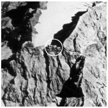
The March/April 1997 issue of The Biblical Chronologist reported on a search I conducted to find the most likely mountain Noah's ark landed on within the geographical region known anciently as Ararat.[15] I programmed my computer to choose the best candidate for the mountain the ark landed on from 1441 elevations in and around the Ararat region, recorded on modern Tactical Pilotage Charts. Each elevation was evaluated quantitatively relative to seven criteria deduced from the Biblical narrative of the Flood. I found that the landing site favored by tradition, Mt. Ararat, was the second most likely mountain for the resting place of the ark. The first most likely mountain was found to be Mt. Cilo, a previously unknown and unsung (in the present context) mountain in the mountainous region to the southeast of Lake Van (Figure 5). My computer search found that Mt. Cilo was sixty-two times more likely than Mt. Ararat to be the mountain the ark landed on.
 |
In the conclusion to that article I wrote:[16]
I am caused to wonder, of course, whether the ark might possibly be discovered one day on Mount Cilo.The present report describes work which has been carried out over the past few years and is currently under way to search Mount Cilo for remains of the ark.
The idea that a wooden vessel might be preserved in recognizable form after 5500 years may seem a little far-fetched at first. But it really isn't—not at such high altitudes. If the ark had landed in a tropical rainforest we could not hold out much hope of any of it surviving to the present time, of course. It would have rotted away long ago. But the summit of Mount Cilo, at an altitude 13,566 feet (over two and a half miles) above sea level, is not tropical rainforest by any means. The most conspicuous landmarks around Mount Cilo are permanent glaciers, not forests.
Wood can be preserved for a very long time at high altitudes. Bristlecone pine wood has been found preserved on the surface of the ground for more than 10,000 years at altitudes in excess of 10,000 feet in the White Mountains of California.[17] The only way to know whether the ark has been preserved on Mount Cilo is to search the mountain to see if it is there.
It was clear, following my computer search for the correct mountain back in early 1997, that a search for the ark on Mount Cilo should be initiated. The primary reason for this has to do simply with truth. Western culture is caught in the grips of a great lie at present, which has been working for some decades to sever Western culture from its roots. The lie is that the Biblical account of remotest history—Creation, Fall, the Flood, the Exodus, the Conquest—is all a fabrication. The result of this lie is that the Bible seems increasingly unrelated to real life today, to scholar and layperson alike. This lie is strongly entrenched at present. A discovery as dramatic as the ark seems necessary to expose and rout it.
There are other reasons as well, of course, such as the illumination of Biblical history and archaeology of the first half of the fourth millennium B.C. such a discovery would occasion. What construction techniques were used in building the ark? How was space alloted within the vessel? What provision was made for lighting the three levels? How were the animals caged? What types of seed grains and other foods were on board? How was the need of fresh water provided for? What household and other artifacts might yet be found on board? A rare window would obviously be opened into life as it was lived 5500 years ago by discovery of the ark.
Though the need was abundantly clear, the means of initiating such a search were not. To bring this into proper focus I must explain that The Biblical Chronologist is, quite deliberately, not the product of a large organization. It has no denominational backing, no technical advisory board, nor even any board of trustees behind it. I deliberately research, write, and publish The Biblical Chronologist by myself with no staff whatsoever.
My reason for this is simply that it appears to be the only way the research at the interface of science and the Bible which needs to be done today can be done. Here is not the place to try to explain all the reasons behind this. I hope, rather, that you will simply agree with me that this keep-it-simple approach seems to be working—that the output of genuine research discovery harmonizing the Bible and science through The Biblical Chronologist has been remarkably large since its inception in 1995.
Now I must immediately add that I hope this brief explanation does not conjure up images of me working in complete isolation. In fact I carry on a fairly extensive correspondence with a large number of individuals who are active in one or more of several key capacities relative to the work of The Biblical Chronologist. Without the help and encouragement of these individuals the ministry of The Biblical Chronologist would suffer greatly and its work would become a very great burden indeed. I suppose these individuals could be regarded as my (unpaid) "staff"; I personally view them simply as Christian friends.
But my point is that while I could see the need, there was no way I had the time to do what needed to be done to begin such a search. "The Ark on Ararat?"article[18] describing the computer search for the correct mountain was merely one step along the way of trying to come to an accurate view of the nature of the Flood—a task which would consume the bulk of my time and energy for most of the following year. A search of Mount Cilo for the ark was an unexpected spin-off project. Important though this search was, it could not justifiably displace my main research thrust of trying to understand the nature of the Flood upon which the ark floated. I needed someone to help with this new project.
For some years previously I had been enjoying a friendly correspondence with Mr. Albert (Bert) Hawley. At about the time I was embarking on my computer-search-for-the-right-mountain project I wrote Bert, "On the research front, I feel like I could keep about four of me employed full-time on different promising research topics just now. Limitless time will definitely be one of the benefits of heaven." At about the time I was finishing up that project Bert wrote back, "I wish I had the training to be one of the four you need to cover the bases in your research!"
I had learned from our correspondence that Bert was a WW2 veteran with flight experience. Such a background would be an obvious advantage for conducting a search of Mount Cilo using aerial photographs. Bert seemed the right man for the job to me, and he had volunteered an interest in helping with research. I wrote back, "Any chance you would be interested in following up on the suggestion that the ark may have landed on Mount Cilo? If I had the time I would at least investigate whether any high-resolution satellite or airplane photos of the mountain exist. … The ark was a big vessel—one does not need fantastic resolution to be able to see such a large object. Mountain-tops are notably cold and arid, which favors preservation of wood. … If I had the time I would definitely pursue this. I don't. Would you be interested?"
Bert responded affirmatively, and dove into the project at once, seeking satellite photo coverage of the mountain available to the general public.
Two years have now passed. Bert has become an expert in obtaining satellite film of Mount Cilo. We have kept the United States Postal Service busy between Illinois and California, where Bert lives, with correspondence, satellite film, and photographic enlargements. We have searched films and photos by microscope, slide projector, and computer scanner. Since September 1998 we have been joined by a second "research associate", Basil Finnegan. And together we now have something to report.
Figure 4 shows an object of considerable interest to the present search. It appears as a barn-like structure on the south side of Mount Cilo in the satellite photo shown. It is estimated to be at an altitude some 1500 feet lower than the summit. We have called it IO3 (Interesting Object #3). The purpose of the present interim report is to publicly advance IO3 as a candidate for the ark, and to detail plans for further investigation of this particular object.
The investigation breaks naturally into two phases. Phase 1 has used available satellite photos of the mountain to search for anything of interest. The pace of research during phase 1 has been at our leisure and the costs have been relatively modest. The purpose of phase 2 is to bring the search to a definitive conclusion. The data necessary to do this are not already available; they can only be obtained through specially designed data-gathering missions. (More on this below.) These missions cannot be conducted at our leisure; they will need to be set to go whenever conditions (particularly snow cover) are right on the mountain (usually mid to late summer). The cost of these missions is relatively high. All expenses in phase 1 have been borne by project members and Aardsma Research & Publishing, under which umbrella The Biblical Chronologist is published. Phase 2 requires additional financial assistance.
Phase 1 has been concerned with identifying all "interesting objects" on or near Mount Cilo using available satellite images. The label "interesting objects" is not meant to imply objects which look like the ark. Rather it means anything which is very roughly the right scale for the ark (within a factor of two or three) and which appears anomalous relative to other features in the photo around it. Only three objects have so far been found which fit even this broad classification, of which IO3 is the third.
While IO3 is a proper member of the IO class, it instigates a sub-class which might be called "very interesting objects" (the VIO sub-class). So far, nothing remotely similar to it or nearly as interesting as it has been located anywhere on or near Mount Cilo.
IO1 was identified as two prominent parallel lines on a low magnification photo of the region; at higher magnification these were seen to be of natural origin. They were shadows in parallel valleys (or rifts) within a snow field.
IO2 appears as several horizontal, cylindrically shaped objects grouped close together on a ridge adjoining Mount Cilo when this ridge is viewed at low angle (Figure 6). They do not appear in the photos we have when this ridge is viewed directly overhead. It is not clear what these are; they may be natural rock formations, though their cylindrical shape is quite different from the usual broken angularity of the rocks which are found all around them. In any event, their cylindrical shape does not seem to suit the Biblical description of the ark, which seems to specify a rectangular vessel (Genesis 6:14–16). By way of contrast, IO3 does display a rectangular appearance suitable to the Biblical description of the ark (Figure 4).
 |
The degree of interest an object commands is seen, from the above three examples, to be related to two criteria: 1. the degree to which the object matches Biblical expectations of the ark (I will call this similarity), and 2. the object's resistance to other explanations of its origin (I will call this resistance). IO1 has low similarity and low resistance. It can be dismissed from further consideration. IO2 has low similarity and medium resistance. It cannot be dismissed, but it does not seem to warrant further effort at this time because of the much higher interest commanded by IO3. IO3 has high similarity and very high resistance, as I will now attempt to show.
The most objective way to assess the similarity of IO3 to the Biblical description of the ark is to conduct a simulation study using a scale model of the ark. The object of such a study is to see how closely a satellite photo of an interesting object can be replicated in the laboratory using a scale model and a simple camera. In a simulation study we set the scale model of the ark up on a table, build a model landscape around it, use a single spotlight for illumination to simulate the sun, and adjust the lighting and camera angles to match those of the satellite photo as closely as possible. We then compare the simulation photo to the satellite photo to assess their similarity.
I used the scale model of the ark shown in Figure 7 to conduct a simulation study of IO3.[19] The model is to scale; the pitch of the roof is guessed at since it is not specified Biblically. The "window" which runs along the top steps up "1 (scale) cubit". The Biblically specified height of 30 cubits has been taken as the height of the side walls, not the height of the peak. I used cotton puffs to simulate the snow field surrounding IO3.
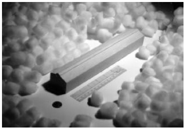 |
Figure 8 shows the result. While my camera angle was not quite right (the shot should have been taken from a slightly more overhead angle) I think the result shown is sufficient to demonstrate that there is a high degree of similarity between the Biblical description of the ark and IO3 as it appears in this particular satellite photo.
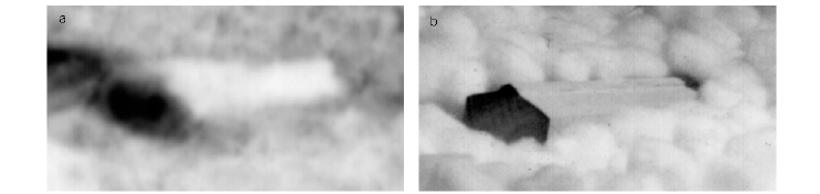 |
Three things not obvious in Figure 8 need to be made explicit here. First, I have oriented the photos to make IO3 and the ark fit conveniently within the width of the area shown. This gives the impression that IO3 is situated horizontally. It is not easy to judge the orientation of an object with respect to horizontal from overhead photographs, but it is clear that IO3 is not situated horizontally on the slopes of Mount Cilo.
In my modeling study I began by crudely approximating the landscape with a plane, tilted up at about 20° from horizontal. A steeper slope would have been better, but it is inconvenient to work with a steeper slope because the model ark is prone to slide down it. I situated the model ark on this plane with its long axis pointing about 45° from the gradient. This is all very rough and does not need to accurately reflect the actual slope under IO3 since I am free to orient the sun (spotlight) and camera in 3-space. But it does reflect my impression from the original photo that IO3 lies upon a substantially sloped surface at a significantly skewed angle. Bert feels the ark is situated with its long axis pointing directly up the mountain.
Second, the back half of the model ark is buried in cotton puffs. This suggests that if IO3 is the ark, then half of it was buried in snow when this satellite photo was taken.
Third, I have deliberately adjusted the scale of the two photos to make the photographic images of IO3 and the model ark comparable in size. I have done this for ease of visual comparison. It is of much interest to go further and ask whether IO3 is the correct absolute size for the ark using the dimensions given in Genesis 6:15. This can be done by comparing the relative scales of these two photos.
Unfortunately, this is complicated somewhat by the fact that the Biblical unit of measure used is the "cubit", and cubits of varying absolute lengths were used in antiquity.
CUBIT, an ancient measure of length. Approximate only, it applied to the length from the elbow to the tip of the longest finger. The Hebrews had two cubits—the ordinary cubit, and a longer one used by Ezekiel in his measurements for the Temple (Genesis 6:16; Deuteronomy 3:11; II Chronicles 3:3; 4:3; Ezekiel 43:13). Estimates vary between 16 inches and 25.2 inches. The Egyptian common cubit was about 17.72 inches; the royal cubit 20.67 inches.[20]
Rather than asking if IO3 is the right size, it makes better sense to ask what length of cubit would be required to match IO3's size to the Biblical dimensions. The answer to this question is 29±3 inches (1σ). The 10% uncertainty in this figure is estimated from uncertainties involved in determining the scales of the two photos.
This is within measurement uncertainties of the 25.2 inch cubit mentioned in the above quote, so the possibility of a match between the absolute size of IO3 and the Biblically specified dimensions of the ark can certainly not be excluded. However, it seems a bit surprising (though hardly impossible, given the great antiquity of this vessel) not to find a match closer to the more usual 18 inch cubit. This decreases the similarity index somewhat in my opinion, which is why I have given IO3 only a "high" rather than a "very high" similarity rating.
One interesting consequence of this requirement is that, if IO3 is the ark, then the ark was even bigger in real life than is commonly believed. The Biblical dimensions of 300 cubits by 50 cubits by 30 cubits are usually converted to feet assuming an 18 inch cubit. This yields 450 feet by 75 feet by 45 feet. This is already a very large vessel; it is one and a half football fields long (measuring goal line to goal line) and nearly half a football field wide. A 25 inch cubit increases this to 625 feet by 104 feet by 63 feet. This is over two football fields in length and over five-eighths of a football field wide.
The resistance rating for IO3 depends upon our ability to devise explanations for it other than that it is the ark. We can immediately divide possible alternatives into two categories: 1. those which regard IO3 as a man made object, and 2. those which regard IO3 as a natural object or natural feature of the landscape.
The impression that IO3 is some sort of man made object results mainly from its rectilinear shape. But the idea that IO3 might be some man made structure other than the ark encounters serious difficulties.
First, its huge size is not conducive to the idea that this is an ordinary building, such as a barn. It is just too large for such an application.
Second, it is very difficult to imagine what function such a huge building could possibly serve at such a high altitude, especially given the fact that there are no roads or even any trails leading to it.
Third, its orientation on the mountain is far from horizontal, as mentioned above. No man made structure is deliberately built on such a steep slope and so far out of plumb. In fact, it would be an extremely difficult task to erect a rectilinear building so far out of plumb.
One might argue that IO3 is a man made building (other than the ark) which was not erected out of plumb—that it came to its present orientation only after it had been constructed. Such a view implies (taking a reasonable view of tectonics in the region) that it must not have been built where it is presently located. But how would it then have been transported to its present location? There are no roads leading to the sight. IO3 is obviously too big to have been flown to the mountain in one piece. A flood of the magnitude of Noah's Flood would be required to float anything to this altitude—which gets us immediately back to the ark. The only other option is that it was built on level ground further up the mountain and has slid to its present position. But satellite images of the mountain strongly suggest that a reasonably horizontal area big enough to construct a building the size of IO3 (even assuming that half of it is not buried under snow) does not exist on the mountain anywhere above the present location of IO3. And any normal building of such size, built upon a hypothetical foundation further up the mountain, would obviously be demolished in the process of removing it from its foundation and sliding it down the mountain.
We may add to all of these difficulties that such a large structure would require a substantial quantity of lumber for its construction. The amount of labor required just to haul such a large quantity of lumber to such a high altitude—well above the tree line—is more or less unthinkable in the first place.
IO3 is highly resistant to explanation in terms of some other man made structure than the ark.
This leaves the second category: explanation of IO3 as some natural object.
While the rectilinear form of IO3 seems immediately contrary to this idea, the possibility that IO3 is nonetheless just some natural object or feature of the landscape cannot be dismissed. In particular we must ask whether snow, rocks, and shadows might have coincidentally converged to create an impression of a rectilinear structure in Figure 8 where no such structure in fact exists.
The most obvious way to answer this question is to view IO3 in a second satellite photo taken 1. on a significantly different date (to change the snow cover), 2. at a different time of the day (to change the shadows), and 3. from a different angle (to change the view). With all these changes one would expect the similarity rating to drop to near zero in the second photo if IO3 in the first photo is, in fact, merely a coincidental conjunction of snow, rocks, and shadows. If, on the other hand, IO3 is the ark, then similarity should be preserved in spite of all these changes.
The satellite photo of IO3 shown in Figure 9 was taken two years and one month prior to the photo of Figure 8. It is taken at a significantly different angle, and, judging from the shadows in the panoramic view of the whole region, at a significantly different time of day. My simulation study photo of it (Figure 9) shows that high similarity is retained. (The 29±3 inch cubit is also retained.) The suggestion that the similarity of IO3 to the ark results merely from a coincidental conjunction of snow, rocks, and shadows appears improbable.
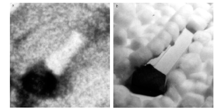 |
Thus, IO3 is found to be also resistant to explanation in terms of some natural object or feature.
By way of contrast, the hypothesis that IO3 is the ark encounters no serious difficulty with respect to presently available data. The Bible informs us that such a vessel was built some time prior to 3500 B.C., that it was carried on the waters of the Great Flood, and that it was deposited within the mountains of the Ararat region. Attention to details within the Biblical narrative of the Flood (Genesis 6–8) leads one to expect that the ark rested near the summit of a mountain which was taller than any of its near neighbors. This observation, when coupled with others from the Biblical narrative and pursued as quantitatively and as rigorously as possible leads to the conclusion that Mount Cilo is by far the most probable landing place of the ark.[21] IO3 is situated on the high slopes of that landing place.
The Biblical narrative leads us to expect that the mountain the ark landed upon was pointed and steeply sloped, rather than broad-topped. We may picture the ark perched somewhat precariously and probably not all that horizontally within the rugged terrain near the summit of Mount Cilo when it first came to rest.
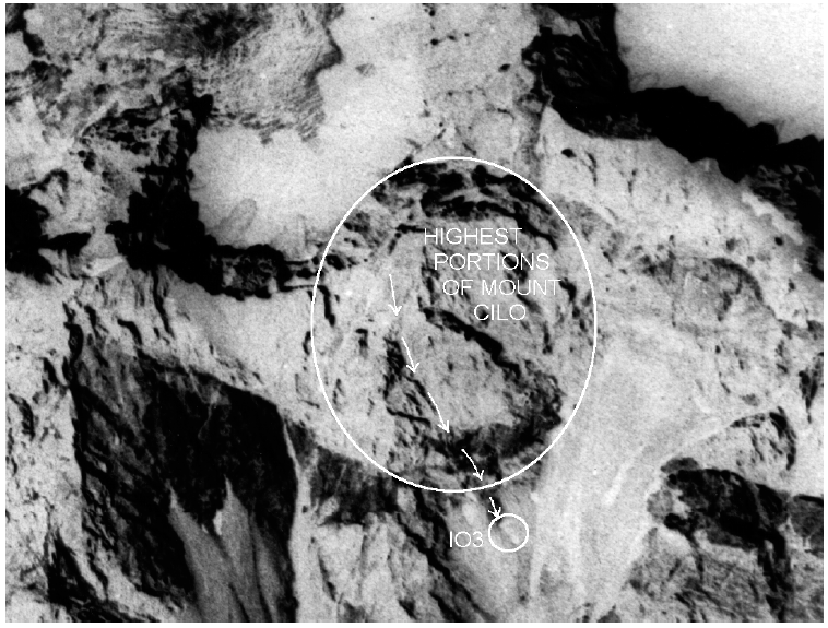
One does not have to imagine a sudden toboggan slide down the mountain to get the ark to the present location of IO3 by any means. IO3 appears too well preserved to have moved from the summit to its present position suddenly; it seems more reasonable to imagine a slow, creeping descent. The ark needs only to have crept along the surface of the mountain at an average rate of about fifteen thousands of an inch per day to have accomplished a journey of 2500 feet in 5500 years. Such small motions might be occasioned, for example, by daily fluctuations in temperature expanding and contracting the entire vessel relative to the ground. A natural path from the summit to the location of IO3 seems to be provided by a relatively shallow ravine on the mountain (Figure 10).
 |
The ark appears to be situated in the upper reaches of a snowfield at present. Simulation studies imply that it is nearly buried in snow, as pointed out above, with only one half of the southwest-facing side of the roof and one end normally exposed (Figures 8 and 9). This makes the vessel difficult to identify in satellite photos taken from the east or from directly overhead. A camera orientation low and in the west seems to offer the best view of the exposed portions of the vessel.
The vessel is probably not visible from the slopes of the mountain above because of the snow cover on the mountain side of its roof. Piling of the snow against the roof is most noticeable in Figure 9, including even ridges in the snow parallel to the vessel on its uphill side.
The lower half of the vessel appears to be buried in a deep drift. The fact that the snow cover appears to be roughly the same in the satellite photos of Figure 8 and Figure 9, taken more than two years apart, suggests that the vessel may be frequently exposed to this extent in late summer and early fall.
The next logical step in this investigation is to obtain current satellite photos of IO3. The photos shown in Figures 8 and 9 were both taken over thirty years ago. The research team has set the goal of obtaining at least one stereoscopic pair of photos late this summer, weather and finances permitting. These will need to be custom ordered from a commercial satellite photography company. Investigation of options is currently underway. Photos are expected to cost around $6,000 per stereo pair.
Successful acquisition of such photos will serve a number of purposes. First, it needs to be verified that IO3 is still where it was over thirty years ago when the photos shown in this report were taken. This step is obviously prerequisite to any (much more expensive) mission to the site.
Second, newer photos should have a significantly improved resolution. This will reduce blurring in the final images and permit finer details to be seen. This in itself may go a long way toward confirming or refuting the identification of IO3 with the ark.
Third, custom photos should allow greater control of camera angle and illumination (i.e., position of the sun in the sky when the photos are taken), giving us the best possible exposure of IO3.
Fourth and final, a stereoscopic pair of photos will allow three dimensional viewing of the region. This will greatly improve our knowledge of the terrain on Mount Cilo and around IO3.
I need to make it very clear that the research team is not claiming IO3 is Noah's ark at this stage. We are unable either to confirm or to refute the possibility that IO3 may be the ark based on the information (satellite photos) we presently have available. IO3 shows significant similarity to the Biblical description of the ark, and it is difficult to find an alternative explanation for this object at this stage. These observations lead us to conclude that IO3 is a good candidate for the ark, and that it warrants further serious investigation.
The claim that an object is the ark can only be responsibly made after: 1. close-up (probably ground-based, on-site) photographs reveal an object which is suitable to the ark both inside and out, and 2. wood from such a visibly suitable structure has been shown by radiocarbon to date to within a few centuries prior to 3520±21B.C. (when the trees from which the ark was constructed would have grown). (This condition is necessary to ensure that one has found the original ark rather than, for example, a medieval replica of it.) Neither of these two conditions has yet been met with IO3 or any other object which has ever been advanced as a candidate for the ark.
Is IO3 the ark? The intention of the research team is to press toward a responsible, defensible validation or refutation of this possibility as expeditiously as possible. Reports on progress will be published in this column in future issues as further information comes available. ◇
The Biblical Chronologist is a bimonthly subscription newsletter about Biblical chronology. It is written and edited by Gerald E. Aardsma, a Ph.D. scientist (nuclear physics) with special background in radioisotopic dating methods such as radiocarbon. The Biblical Chronologist has a threefold purpose: to encourage, enrich, and strengthen the faith of conservative Christians through instruction in Biblical chronology, to foster informed, up-to-date, scholarly research in this vital field within the conservative Christian community, and to communicate current developments and discoveries in Biblical chronology in an easily understood manner. An introductory packet containing three sample issues and a subscription order form is available for $9.95 US regardless of destination address. Send check or money order in US funds and request the "Intro Pack." The Biblical Chronologist (ISSN 1081-762X) is published six times a year by Aardsma Research & Publishing, 412 N Mulberry, Loda, IL 60948-9651. Copyright © 1999 by Aardsma Research & Publishing. Photocopying or reproduction strictly prohibited without written permission from the publisher.
|
^ Gerald E. Aardsma, "Chronology of the Bible: 5000–3000 B.C.," The Biblical Chronologist 2.4 (July/August 1996): 1–5.
^ Gerald E. Aardsma, "The Cause of Noah's Flood," The Biblical Chronologist 3.5 (September/October 1997): 1–14.
^ Gerald E. Aardsma, "Noah's Flood at Devon Island," The Biblical Chronologist 3.4 (July/August 1997): 1–16, and Gerald E. Aardsma, "The Cause of Noah's Flood," The Biblical Chronologist 3.5 (September/October 1997): 1–14.
^ Gerald E. Aardsma, "Zoogeography and Noah's Flood," The Biblical Chronologist 4.1 (January/February 1998): 1–7.
^ Gerald E. Aardsma, "Noah's Flood at Elk Lake," The Biblical Chronologist 2.6 (November/December 1996): 1–13.
^ Gerald E. Aardsma, "Radiocarbon Dating Noah's Flood," The Biblical Chronologist 3.6 (November/December 1997): 1–11.
^ Rivka Gonen, "The Chalcolithic Period," The Archaeology of Ancient Israel, ed. Amnon Ben-Tor (New Haven: Yale University Press, 1992), 80.
^ Gerald E. Aardsma, "Radiocarbon Dating Noah's Flood," The Biblical Chronologist 3.6 (November/December 1997): 1–11.
^ Gerald E. Aardsma, "The Cause of Noah's Flood," The Biblical Chronologist 3.5 (September/October 1997): 12–13, and Gerald E. Aardsma, "Zoogeography and Noah's Flood," The Biblical Chronologist 4.1 (January/February 1998): 1–7; Gerald E. Aardsma, "Space Rock Impacts and Noah's Flood," The Biblical Chronologist 4.2 (March/April 1998): 5, 10; Gerald E. Aardsma, "Biblical Chronology 101," The Biblical Chronologist 4.3 (May/June 1998): 6.
^ Gerald E. Aardsma, "Biblical Chronology 101," The Biblical Chronologist 4.3 (May/June 1998): 6–10.
^ See for example: G. T. Cook, A. J. Dugmore, and J. S. Shore, "The Influence of Pretreatment on Humic Acid Yield and 14C Age of Carex Peat," Radiocarbon 40.1 (1998): 21–27.
^ Calibration of these radiocarbon dates was carried out using the bidecadal dataset of CALIB 3.0.3. See M. Stuiver and P. J. Reimer, "Extended 14C Data Base and Revised CALIB 3.0 14C Age Calibration Program," Radiocarbon 35.1 (1993): 215–230.
^ Seamas Caulfield, R. G. O'Donnell, and P. I. Mitchell, "14C Dating of a Neolithic Field System At Céide Fields, County Mayo, Ireland," Radiocarbon 40.2 (1998): 629–640.
^ My appreciation to R. E. Wehrwein for special help in obtaining library materials used in the preparation of this article.
^ Gerald E. Aardsma, "The Ark on Ararat?," The Biblical Chronologist 3.2 (March/April 1997): 1–12.
^ Gerald E. Aardsma, "The Ark on Ararat?," The Biblical Chronologist 3.2 (March/April 1997): 12.
^ C. W. Ferguson, Barbara Lawn, and H. N. Michael, "Prospects for the Extension of the Bristlecone Pine Chronology: Radiocarbon Analysis of H-84-1," Meteoritics Vol. 20, No. 2, Part 2 (30 June 1985): 415–421; C. W. Ferguson, "Bristlecone Pine: Science and Esthetics," Science 159 (23 February 1968): 839–846.
^ Gerald E. Aardsma, "The Ark on Ararat?," The Biblical Chronologist 3.2 (March/April 1997): 12.
^ I would like to thank my 17 year old son, Stephen, for constructing this model for me.
^ "Cubit," The Encyclopedia Americana, vol. 8 (Chicago: Rand McNally, 1962) 289.
^ Gerald E. Aardsma, "The Ark on Ararat?," The Biblical Chronologist 3.2 (March/April 1997): 1–12.