
| |
| Volume 2, Number 1 | January/February 1996 |
Scholars have puzzled over the route of the Exodus for quite a few centuries. Today one can find a selection of theories regarding it in most standard Bible encyclopedias.[1] Scholars' inability to determine the true route of the Exodus was understandable a generation ago—it is inexcusable today.
A generation ago, scholars had only the Biblical text and the geography of the Sinai peninsula to go on. This was simply too little information to uniquely determine the actual route the Israelites took from Egypt to Palestine. In the last several decades, however, the situation has changed entirely. The Biblical and geographical data has now been strongly supplemented with data from the field of Biblical archaeology. In particular, extensive surface surveys have been carried out in the Sinai peninsula. The nature of the resultant archaeological data is such that the encampments made by the Israelites at the time of the Exodus cannot help but be exposed by them.
Unfortunately, modern conservative scholars have largely eschewed the Biblical archaeological data bearing on this question. This approach to the problem has been dictated by necessity, however, not preference. It has been a necessity because the Biblical chronological framework which these scholars have assumed misdates the Exodus by a full millennium. This gross chronological error prohibits any meaningful alignment of any of the Biblical narrative prior to the time of Eli and Samuel with any significant Biblical archaeology datum. As a result scholars have been unable to make any sense of the archaeological data, and they have generally opted simply to ignore them.
Since the problem which gave rise to this erroneous Biblical chronology has been discovered and mended, it is no longer necessary to labor under this handicap.[2] It is now possible, for the first time, to bring the data of archaeology to bear on this problem. The present article introduces a number of the exciting discoveries which result when this is done.
This article is not everywhere as easy to follow as I would have liked. I have been forced by space constraints to abridge the discussion at a number of points. You can compensate for this to a large extent by taking the time to read through the Bible references provided in the article, and by thoroughly digesting its two figures. The extreme importance of the present discoveries cannot be overstated; I think you will find whatever effort you expend to thoroughly understand this matter to be well worth your while.
In the previous issue[3] I introduced a paper by Eliezer Oren and Yuval Yekutieli[4] describing sites located by Oren through surface surveys conducted in the Sinai peninsula between 1972 and 1982. I showed that the pottery from these sites completely satisfies our expectations, based on the new Biblical chronology, of the Israelite encampments at the time of the Exodus. I suggested, on this basis alone, that these sites should, in fact, be recognized as the modern-day remains of those ancient encampments.
In the present article I resume this discussion of the Oren and Yekutieli sites, bringing additional evidence forward to show that what Oren and Yekutieli have found, in fact, are the first three encampments which the Israelites made after leaving Egypt. I begin with a brief look at more of the archaeology of these sites, and then turn to a detailed discussion of their placement on a map of the Sinai peninsula relative to the Biblical information regarding the early route of the Exodus.
What were the early encampments of the Israelites like? Did everybody pitch their tents in neat "city block" fashion, as is sometimes depicted in Sunday school illustrations?
In point of fact, the Biblical record suggests the Israelite camps prior to Mount Sinai were unstructured. While the Israelites were at Mount Sinai, God specified a unique arrangement of the camps which, we must suppose, was only subsequently adhered to.[5] Thus it seems most probable that the initial Exodus encampments were unstructured.
Imagine that first day's journey from Rameses to Succoth. Picture two million people hurrying along an ancient road away from Egypt, carrying what earthly possessions they are able and accompanied by their flocks. Obviously, such a large group would be spread out over a considerable distance along the road. (I calculate that two million people walking 50 abreast with 1 yard between rows of 50 would form a column nearly 23 miles long.) After walking from probably before sunrise until probably after sunset they stop at last and set up camp. Their camp must also have stretched for a number of miles along the road.
In fact, the present-day remains which Oren and Yekutieli found suggest just such a picture. Their research does not show singular, enormous, individual campsites; rather it reveals discrete clusters of many sites of various sizes along an ancient roadway. These clusters are not arranged in "city block" fashion. Rather, they reveal an unstructured arrangement.
I do not mean to suggest that these clusters are devoid of all organization, by any means. In fact, they exhibit just the kind of natural organization one would expect of the tribally oriented, pastoral Israelites. Oren and Yekutieli describe what they found as "clusters of sites with large settlement units at their center and smaller settlements at their margins".[6] Their description suggests that the large sites were the central hub of activity for one or more of the Israelite tribes. Around the large sites were medium size sites which, they suggest, represent the living quarters of families. Around the periphery of these were small sites which they identify as the campsites of shepherds—those who watched the flocks.
The size of these clusters is certainly suitable to the number of people involved in the Exodus. The archaeological data suggest that discrete encampments of the whole population were spread out along the road for a distance of roughly twenty miles, and that they covered an area in excess of four square miles.
I always find it exciting when archaeologists unwittingly use words to describe what they have found which are identical to those which the Bible writer used of the same site or event thousands of years before. In the present case Oren and Yekutieli observe "it looks as if the inhabitants lived in booths, tents or lean-tos."[7] Compare this with the Biblical description of the structures which the Israelites lived in along the route of the Exodus. This description is given in Leviticus 23:33–43 in connection with the Feast of Booths celebration. Verses 42 and 43 say:
You shall live in booths for seven days; all the native-born in Israel shall live in booths, so that your generations may know that I had the sons of Israel live in booths when I brought them out from the land of Egypt.
Bear in mind that Oren and Yekutieli were totally unaware that these sites might correspond in any way to the Biblical Exodus event. Indeed, they proffer the idea that pastoral tribesmen lived at these sites for a period of time, and suggest that these tribesmen penetrated into Egypt at the end of the Old Kingdom, helping to bring about its collapse by the burdensome addition of their numbers to a supposedly already "overpopulated and drought stricken" delta region. They did not connect these sites with the Exodus at all.[8]
While Oren and Yekutieli's historical reconstruction may be faulty, one cannot help but be impressed by their ability when it comes to the archaeological reconstruction of these sites after four and a half thousand years.[9] And one cannot help but be impressed by how readily their archaeological data harmonize with what the Bible records of the Exodus encampments.
I will now turn to a discussion of the information which the Bible provides regarding how the early route of the Exodus should appear when drawn on a map. I call this information the cartographic evidence.
The cartographic evidence is gleaned entirely from the Biblical text, mainly from the book of Exodus. The principal passages are Exodus 12:33–39, Exodus 13:17–14:31, and Exodus 15:22. Here is a list of important cartographic evidences from these passages:
The Exodus was staged from an Egyptian city called Rameses (Ex. 12:37; Num. 33:5).
The first encampment was at Succoth, which was located outside the borders of Egypt (Ex. 12:37–39; Num. 33:5).
The second encampment was at Etham, which was located on the edge of a wilderness (Ex. 13:20; Num. 33:6).
The route of the Exodus doubled back from Etham (Ex. 14:1–2).
The third encampment was at Pi-hahiroth, which was located on the shore of a sea (Ex. 14:2; Num. 33:7).
The sea at Pi-hahiroth was capable of being wind-dried[10] and crossed by two million people in a single night (Ex. 14:21–22).
Pi-hahiroth was adjacent to the wilderness of Shur (Ex. 15:22; Num. 33:8).
The wilderness of Shur was, apparently, the same wilderness that Etham was on the edge of since it is called "the wilderness of Etham" in Numbers 33:8.
I need to emphasize the role of these cartographic evidences in the present discussion before proceeding. While they can be used to eliminate innumerable imaginable routes for the Exodus (for example, all routes which do not have one point adjacent to a sea are immediately eliminated by them), they are incapable of narrowing to a single possible route, as the many routes which have been postulated up to the present time clearly show. (The Sinai peninsula is surrounded by seas, for example, probably all of which have been suggested as candidates for the "Red Sea" crossing at one time or another.)
One must start with the archaeological evidence, interpreted within a sound Biblical chronological framework as we have done, to locate whatever suitable encampment sites there may be, and then apply these cartographic evidences to the archaeologically identified sites. If the archaeologically identified encampment sites do not satisfy the cartographic evidences, then we know that something is still amiss and the search for the route of the Exodus must somehow continue along different lines. If, however, the archaeologically revealed sites do naturally and automatically satisfy these evidences, then we have considerable grounds, beyond just the local archaeology of the individual sites, for believing we have solved the problem of the early portion of the route of the Exodus correctly.
The archaeological sites which we will now apply these cartographic evidences to are those revealed by Oren and Yekutieli's survey data. Three discrete clusters of sites along the ancient road connecting Egypt and Canaan are revealed by these data, as shown in Figure 1.
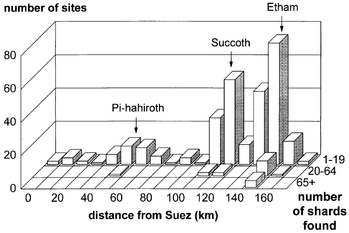 |
I suggest that these three clusters correspond to the first three encampments of the Israelites. The one in the middle corresponds to the first encampment at Succoth, the one on the right to the second encampment at Etham, and the one on the left to the third encampment at Pi-hahiroth.
The locations of the apparent hubs of these three sites, together with the route of the Exodus which they imply, are shown in Figure 2. I will discuss this figure below in relation to the eight cartographic evidences listed previously. Before I do, however, I need to deal with an apparent problem which many may be wondering about at this stage.
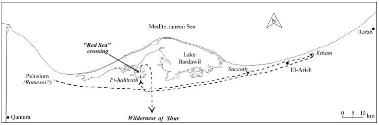 |
The sites which Oren and Yekutieli found are located on the coastal plain of north Sinai, as shown in Figure 2. These sites, and the route of the Exodus which I have drawn, lie along the ancient road which connected Egypt and Canaan. Doesn't this conflict with Exodus 13:17–18? These verses say:
Now it came about when Pharaoh had let the people go, that God did not lead them by the way of the land of the Philistines, even though it was near; for God said, "Lest the people change their minds when they see war, and they return to Egypt." Hence God led the people around by the way of the wilderness to the Red Sea;…
Most scholars interpret these verses to mean that the Israelites did not use the north Sinai road at all during the Exodus. (Some even go so far as to say that God "forbade" the Israelites to use this road, though the text certainly says no such thing.) I suggest these verses should be understood in a different way.
The common approach to these verses equates "the way of the land of the Philistines" with the ancient road in question. I have attempted to determine what evidence this equation is based on, but have little to show for my effort. As best I can determine "the way of the land of the Philistines" is only ever mentioned in the Bible in this one verse, and I have been unable to find any ancient extra-Biblical mention of "the way of the land of the Philistines" at all. Thus, if I have not overlooked anything, it appears the assignment of this Biblical phrase to the north Sinai road is based entirely upon this one Biblical reference.
This Biblical reference provides no explicit description of where this road was located, of course. It only tells us that "the way of the land of the Philistines" "was near." Near what? Apparently, near the people when Pharaoh had let them go. Where would this be? This question is not easy to answer definitively. It could obviously be Rameses, in Egypt. If so, then the equation of "the way of the land of the Philistines" with the north Sinai road would seem to be demanded. But it could also apply to one of the later stops along the route. In particular, I suggest, it could apply to Etham. This possibility seems probable along several lines of reasoning.
First, it seems unnatural to call the north Sinai road "the way of the land of the Philistines" since north Sinai was not part of the land of the Philistines. From a reference frame located in Egypt, it would seem more appropriate to call this road through the north Sinai desert "the way of the wilderness to the land of the Philistines." This, in fact, is the way in which the other route mentioned in the Biblical reference in question is named. It is called "the way of the wilderness to the Red Sea". Even the abbreviated form, "the way to the land of the Philistines", might be appropriate for this north Sinai road, but the text says of, not to.
Second, please note that the reason given for not taking "the way of the land of the Philistines" is that the people were not yet ready for war. There would be no threat of war along this ancient road through the uninhabited desert of north Sinai. The threat of war would only arise if Israel passed beyond the desert into the fertile, inhabited region of Canaan. In fact, according to the route shown in Figure 2 they only went as far as Etham "on the edge of the wilderness".
These considerations seem to converge on the single idea that "the way of the land of the Philistines" should be properly located in Philistia, not the north Sinai desert. I suggest that in actual ancient usage "the way of the land of the Philistines" referred only to that portion of the road beyond Etham—the portion of the road which actually ran through Philistia, and not its extension across the north Sinai desert.
I suggest the purpose of these verses is not to inform the reader that the Israelites stayed off the north Sinai road. Rather, their purpose is to explain why the Conquest of Canaan was not launched from Etham.
Such an explanation is surely necessary when we realize (as any ancient reader of these verses would have) that, having achieved Etham, the Israelites were on the very threshold of Canaan. Why did they not immediately begin the Conquest from that point? Why did they turn back? For that matter, why didn't they come back to Etham and initiate the Conquest from there after the drowning of the Pharaoh and his army at Pi-hahiroth? Why did they leave the road at Pi-hahiroth and launch out through the wilderness of Shur instead (see Figure 2)? The intent of Exodus 13:17–18 is not to make us believe that the Israelites never set foot on the ancient road linking Egypt and Canaan across the north Sinai desert at the time of the Exodus; rather, its intent is to provide answers to these questions—questions which would surely be obvious to anybody who was familiar with the location of the Biblical Etham.
One might, I suppose, ask why God would lead the Israelites along the route I have drawn, to the archaeological site I have identified as the Biblical Etham (see Figure 2), on the very threshold of Canaan, if it was not His purpose for them to enter Canaan that way. Wouldn't God have led them directly "by the way of the wilderness to the Red Sea" right from the start, since that was the route by which He intended they should enter Canaan?
The Biblical narrative provides the answer to this question. It shows that God was not too concerned about getting Israel to Canaan as quickly and efficiently as possible at this point in their journey. Indeed, it was the Egyptians, not the Israelites, who were the focus of God's plan during this portion of the narrative.
Exodus 14:1–4 is where we read that God told Moses to turn back from Etham. There we are told that this instruction was given specifically to cause Pharaoh to conclude that the Israelites were aimlessly wandering about so he would come out after them and try to drive them back to slavery in Egypt. Exodus 14:4 informs us that God's purpose in this plan was to teach the Egyptians that He, and not Pharaoh or any of their idols, was God.
It would be entirely wrong to suppose that God's plan to teach the Egyptians this lesson was a last minute scheme hatched as an afterthought along the way to Canaan. God has no last minute schemes. Rather, we must conclude that this purpose was fixed before the Exodus ever began, and that the entire early route of the Exodus was designed by God with this singular purpose in mind.
God did not lead the Israelites into Canaan "by the way of the land of the Philistines", but He did cause them to take the ancient road across the north Sinai desert when they left Egypt nonetheless, that the Egyptians might know that He was the Lord.
I have tentatively identified the extensive ancient ruins called Pelusium with the Biblical Rameses in Figure 2. I have done this on the basis of a single consideration. I have assumed that the individual encampments were separated by a distance which could be traversed in a single day, unless the text explicitly states otherwise (as in Numbers 33:8, for example, where a three day journey is specified between two encampments). The distance between Pelusium and the point I have shown as Succoth is about sixty miles. This is already a very long distance for a single day's walk (though not impossibly so), yet Pelusium is the closest site to Succoth which seems a reasonable candidate for the Biblical Rameses.
As the assumption of a single day's journey between encampment sites is not mandated by the Biblical text, the identification of Pelusium with Rameses is not certain. I put it forward only as what seems at this time to be a likely possibility.
I have been unable to locate any report of archaeological work at Pelusium which might confirm or deny this identification. The earliest levels appear to be below the present-day water table at this site, which possibly explains the lack of pertinent archaeological information.[11]
The location of Succoth shown in Figure 2 is well outside the boundaries of ancient Egypt, in keeping with the second cartographic evidence listed above.
The name Succoth means booths. The implication is that this name was given to the first encampment—which was characterized by booths, as we have already seen—by the Israelites themselves. This has as a further implication the possibility that the site was otherwise unnamed.
In fact, the placement of Succoth shown in Figure 2 appears to be well removed from any other permanent feature (such as a town or village) of this period.
The third cartographic evidence listed above is that Etham was located on the edge of a wilderness. After discussing the near inability of the desert of north Sinai to support any permanent settlement, Oren and Yekutieli show that the location of their rightmost cluster of sites, which I have identified as Etham, is suitably situated on the edge of the modern-day desert as follows:[12]
Next to these unattractive conditions, there exist in the northeastern Sinai, between Rafah and El Arish, better ecological conditions that are conducive to permanent settlement and to a combination of a pastoral mode of life with rural agriculture.Thus, the third cartographic evidence is satisfied.
The fourth cartographic evidence is that the route of the Exodus doubled back from Etham. Figure 2 shows immediately that this requirement is met.
The fifth cartographic evidence is that Pi-hahiroth must be located on the shore of a sea. Here again Figure 2 shows immediately that this requirement is met. This site is Oren and Yekutieli's site BEA34, which they describe as "one of the largest sites" they discovered.
Numbers 33:7 says Pi-hahiroth "faces Baal-zephon". As with nearly all of these early sites, scholars are uncertain of the location of Baal-zephon. However, one very strong candidate which has been suggested in the past is located on a hill on the narrow natural earth dam which separates Lake Bardawil from the Mediterranean Sea, a little west of its most northerly point. This proximity lends additional support to the identification of site BEA34 with Pi-hahiroth.
The sixth cartographic evidence is that the sea which Pi-hahiroth is located next to must be capable of being wind-dried and crossed by two million people in a single night. This sea is called the "Red Sea" in Exodus 15:22.
The name "Red Sea" is a study in itself; scholars are unsure of the proper translation of the Hebrew yam-suph and altogether uncertain of the location of the body of water referred to in this verse. The Bible seems to use yam-suph of several different bodies of water, and it seems best to regard it as a somewhat generic designation, parallel perhaps to our use of the word ocean. One thing which all scholars I have read agree upon is that it is a mistake to naively equate the "Red Sea" of Exodus 15:22 with the modern-day Red Sea or either of its extensions—the Gulf of Suez or the Gulf of Aqaba—which one will find on any modern map of the Sinai peninsula.
Modern scholars seem generally to prefer to translate the yam-suph of Exodus 15:22 as "Sea of Reeds". The New American Standard Bible, which I personally prefer because of its high standard of scholarship, translates yam-suph as "Red Sea" in the verse under discussion, but provides the marginal note, "Literally, Sea of Reeds".
The conservative scholar Kenneth A. Kitchen says:[13]
The yam-suph would not be the Red Sea of today; this is no problem, as the Hebrew term corresponds to Egyptian tjuf, "papyrus," and should here be rendered "sea of reeds." The Sea of Reeds would appear to be water bordered by reed-swamps in which papyrus might grow…
The lagoon of Lake Bardawil north of Pi-hahiroth appears to be a marshy saltwater lake. It suits Kitchen's expectation of yam-suph, given in the previous quote, very well.
In the Rand McNally Bible Atlas, Emil G. Kraeling says regarding Lake Bardawil:[14]
On certain portions of this lake there are big areas of rushes, so that the name "Sea of Reeds" would be an appropriate designation.
So much for the name; now let us turn to the question of whether this body of water is capable of being wind-dried. Here is what Kraeling goes on to say about Lake Bardawil:
The lake is forty-five miles long and thirteen miles wide. Major C. S. Jarvis, one-time governor of Sinai, describes it as an enormous clay pan about six to ten feet below the level of the Mediterranean Sea, and separated from the sea by a very narrow strip of sand, one to three hundred yards in width. The normal condition of the lake, he says, is that of a vast salt-encrusted pan. … According to Jarvis a strong east wind causes a heavy sea on the coast of Sinai—a much bigger one than a northerly gale. This causes the waves to break through the narrow spit of sand at a half-dozen places and in a short time floods the whole salt-pan of Lake Bardawil to a depth of five or six feet.
Thus, it appears that there is no problem with the lagoon north of Pi-hahiroth in Figure 2 being wind-dried. Indeed, it appears from Jarvis' description that the lake is dry more often than it is flooded today. This is contrary to the Biblical text which records the normal state of the lake as flooded at the time of the Exodus (Exodus 14:27). This is not a problem, however, as such differences in the behavior of the lake can very reasonably be accounted for by factors which can easily change in four and a half thousand years. For example, a single violent storm could easily have altered the narrow spit of sand which separates the lake from the Mediterranean, closing off channels which might previously have linked Lake Bardawil with the Mediterranean.
The crossing of the lagoon in a single night is also not a problem. The lagoon is presently just over three miles across. This distance can easily be covered in forty-five minutes by a person who is walking briskly. The real question, however, is whether two million people could funnel through the wind-dried path through the lagoon in time. The answer to this question depends upon how wide the path through the lagoon was, which we are not told.
However, one does not require a very wide path to do the job. If we assume, to get a feel for this, that the Israelites had ten hours to get across, that they walked at the rate of four miles per hour, and that each person took up an area of six square feet while walking across, then I calculate that the path through the lagoon would only need to be about twenty yards wide. As the lagoon itself is some three miles wide, this would leave plenty of room for the waters to be "like a wall to them on their right hand and on their left" (Exodus 14:29).
Thus, the sixth cartographic evidence is completely satisfied.
Before proceeding to the final two cartographic evidences, there is one other point in connection with this lagoon which seems worth mentioning. I have no data on the depth of this specific lagoon, but presume it is not much different from the rest of the lake. The Rand McNally quote given above suggests the bottom of the lake is six to ten feet below the level of the Mediterranean. This implies that the lake could be naturally filled with water to this depth—the actual depth at any given time being dependent, of course, upon the tides and wind. Thus, it appears that this lagoon could be filled with a sufficient depth of water to drown Pharaoh and his army, as the Biblical narrative demands.
The final two cartographic evidences are that Pi-hahiroth must be located adjacent to the wilderness of Shur, and this wilderness must also be the one which Etham was on the edge of. Other references to Shur in the Bible seem to place it consistently to the east of Egypt (Genesis 25:18; 1 Samuel 15:7; 1 Samuel 27:8). If we regard it simply as the desert which stretches between Egypt and Palestine, in agreement with most scholars, then the seventh and the eighth cartographic evidences are immediately and naturally satisfied.
How confident can we be that the early route of the Exodus shown in Figure 2 is basically correct?
A person's degree of confidence should, of course, be based on evidence, not wishful thinking, traditional belief, or majority opinion.
In the present case we have some pretty impressive evidence.
To begin with, we have detailed archaeological evidence within a highly specified chronological framework. The chronological framework was specified without any awareness of what the archaeological data from the Sinai peninsula would reveal. Said simply, the new Biblical chronology—the one which restores 1000 years to 1 Kings 6:1— predicted a very narrow period of time in which the Israelite encampments would be found, and encampments which look remarkably like what one would expect the Israelites to have made have been found exactly within that narrow time period. Furthermore, no encampment sites even remotely resembling something the Israelites might have made at the time of the Exodus have ever been found anywhere in the entire Sinai at any time outside this narrow time window, despite considerable effort by many competent individuals to do so.
This is a serious problem for the conventional dates of the Exodus. How can their total failure to find archaeological evidence of even a single Israelite encampment anywhere in the entire Sinai peninsula be explained? It is no good saying that one cannot expect such evidence to be preserved after three and a half thousand years, for the new Biblical chronology finds its expected evidence has been preserved quite well after four and a half thousand years.
When the Biblical cartographic evidence is added to these chronological and archaeological considerations there seems little remaining impetus for doubt. The archaeologists found exactly three clusters of sites along the ancient road connecting Egypt and Canaan; the Biblical narrative informs us that exactly three Israelite encampments preceded the trek into the wilderness of Shur. The Bible tells us that one of these encampments was on the edge of the wilderness of Shur, and one on the shore of a sea which could be wind-dried and crossed by the Israelites in a single night. The sites discovered by the archaeologists match these requirements exactly. The Bible tells us that Succoth was located outside the borders of Egypt; the sites found by the archaeologists are so located. The Bible tells us that the encampment on the shore of the sea at Pi-hahiroth must have been closer to Egypt than the encampment on the edge of the wilderness at Etham, for the Israelites turned back from Etham to arrive at Pi-hahiroth. The sites discovered by the archaeologists exhibit this relationship as well.
I judge the evidence to be overwhelmingly conclusive—the early portion of the route of the Exodus has been found. ◇
The cover of the December 18, 1995 issue of Time magazine featured the question, "Is the Bible Fact or Fiction?" That the magazine would certainly not answer this question with an unequivocal yes was foreshadowed by the cover's byline which read, "Archaeologists in the Holy Land are shedding new light on what did—and didn't—occur in the greatest stories ever told".
Inside the magazine, on pages 62 through 69, was an article by Michael D. Lemonick bearing the title, "Are the Bible's Stories True?" I would like us to take a critical look at this article in this class session. It exposes much of the nature of the times in which we live, the urgency of the present hour in the defense of true Christianity, and the pivotal role of Biblical chronology in it all.
Lemonick's message can be summarized in four statements:
Reasonable people don't mind if much of the Bible is false, so long as it is a little bit true.
Most scholars do not believe pre-monarchical Biblical history is true.
Most scholars agree Biblical history after the reign of Solomon is true.
The final answers from archaeology aren't in yet; a single discovery could totally change the entire picture.
The first of these four statements was the overall, implicit message of the article. It was found most explicitly on page 65:
Jewish and Christian ultraconservatives don't like hearing that parts of the Bible could be fictional. Atheists can't wait to prove the whole thing is a fairy tale. And even for the moderate majority, the Bible underlies so much of Western culture that it matters a great deal whether its narratives are grounded in truth.and at the end of the article, particularly the closing quote by Cross:
"To suggest that many things in the Bible are not historical is not too serious. But to lose biblical history altogether is to lose our tradition."
While I felt that most of Lemonick's article was an honest attempt at fair-mindedness, a distinct bias comes through with this implicit message. The bias is against those who find the complete historicity of the Scriptures a matter of vital importance. These are separated out as "ultraconservatives" by Lemonick; set apart from the "moderate majority".
Contrary to Lemonick's intimations, however, you do not automatically become a religious extremist by being concerned about the historical accuracy of the entire Bible. All Christians from all ages (not just Lemonick's "ultraconservatives") who have known why they believe what they believe have been concerned about this vital issue. And there is a great deal more at stake here than mere cultural propriety. As we have previously seen, all of Christian apologetics hinges on this issue. (Recall: "if the Bible can be convicted of any falsehood in regard to history, then there is no basis for the claim that Christianity is true.")[15]
The historicity of the Bible is the issue which distinguishes liberal and conservative Christians. Those who reject the historical accuracy of the Biblical historical narratives are liberals; those who accept it are conservatives. The article clearly espouses a liberal view of Scripture. Please do not be taken in by the propaganda that this is the normative view of reasonable people; it simply isn't.
I found Lemonick's grasp of the present situation in the field of Biblical archaeology to be impressive and largely correct. The second and third statements listed above are quite accurate. You should know by now that this phenomenon is due entirely to the millennium which is missing in traditional Biblical chronology just prior to the monarchical period in Israel. (If you don't, please read my book[16] and the back issues of this newsletter.)
Those who rejoice to employ archaeology in tearing down Biblical historicity (but generally insist that it is an abuse of objective scholarship and sound scientific procedure to bring archaeology to the defense of Scripture) feel that they have routed the enemy from the fields of Genesis through Judges. They have now launched an all-out campaign against the historical accuracy of Samuel and Kings. They do not understand that their easy "victory" over Genesis through Judges was entirely hollow—that all they have really done is help emphasize that a number was accidentally dropped from the text of Scripture a very long time ago. We must do what we can to try to make this clear to those impressed by their apparent success. (For my part, I have written a letter to the editor of Time.) In the meantime we can predict that the attackers are in for a rude shock in their battle for Samuel and Kings, for the traditional chronology of these books is basically sound.
Lemonick's final point—that a single discovery could change everything—could be considered as after-the-fact prophetic, even though he intended an archaeological rather than chronological discovery. And it was a little remarkable to find Lemonick saying, "it is perplexing that no evidence of the Israelites' passage [across the Sinai peninsula at the time of the Exodus] has been found" (page 68) while I was in the process of writing up the clear archaeological evidence of that passage which I had recently been led, by the new Biblical chronology, to find. (See the lead articles of this and the previous issue of The Biblical Chronologist.) ◇
The Biblical Chronologist is a bimonthly subscription newsletter about Biblical chronology. It is written and edited by Gerald E. Aardsma, a Ph.D. scientist (nuclear physics) with special background in radioisotopic dating methods such as radiocarbon. The Biblical Chronologist has a threefold purpose: to encourage, enrich, and strengthen the faith of conservative Christians through instruction in Biblical chronology, to foster informed, up-to-date, scholarly research in this vital field within the conservative Christian community, and to communicate current developments and discoveries in Biblical chronology in an easily understood manner. An introductory packet containing three sample issues and a subscription order form is available for $9.95 US regardless of destination address. Send check or money order in US funds and request the "Intro Pack." The Biblical Chronologist (ISSN 1081-762X) is published six times a year by Aardsma Research & Publishing, 412 N Mulberry, Loda, IL 60948-9651. Copyright © 1996 by Aardsma Research & Publishing. Photocopying or reproduction strictly prohibited without written permission from the publisher.
|
^ See Figure 1 of the previous issue for a visual representation of some of these theories.
^ Gerald E. Aardsma, A New Approach to the Chronology of Biblical History from Abraham to Samuel, 2nd ed. (Loda IL: Aardsma Research and Publishing, 1993).
^ Gerald E. Aardsma, "Yeroham—The True Mt. Sinai?," The Biblical Chronologist 1.6 (November/December 1995): 1–8.
^ E. D. Oren and Y. Yekutieli, "North Sinai During the MB I Period—Pastoral Nomadism and Sedentary Settlement," Eretz-Israel 21 (1990): 6–22.
^ Numbers 2.
^ E. D. Oren and Y. Yekutieli, "North Sinai During the MB I Period—Pastoral Nomadism and Sedentary Settlement," Eretz-Israel 21 (1990): 7–8. (English translation provided by Marganit Weinberger-Rotman.)
^ E. D. Oren and Y. Yekutieli, "North Sinai During the MB I Period—Pastoral Nomadism and Sedentary Settlement," Eretz-Israel 21 (1990): 8. (English translation provided by Marganit Weinberger-Rotman.)
^ Notice that Oren and Yekutieli's interpretation of these sites is, in effect, an Exodus in reverse. This is not surprising. It is impossible for Oren and Yekutieli to tell which came first, the campsites or the collapse of the Old Kingdom. The two are simply too close in time to be resolved by any physical dating method.
It is as if Oren and Yekutieli's archaeology has provided them with disconnected frames, or slides, from a motion picture of the past. These slides can be used to tell many different stories about the past, depending upon the order in which one chooses to project them onto the screen. (See my previous discussion of this point. [Gerald E. Aardsma, "Biblical Chronology 101," The Biblical Chronologist 1.3 (May/June 1995): 5.]) Oren and Yekutieli have projected them in one of the many possible wrong sequences. To learn the proper chronological sequencing of these slides, one must turn to the Bible.
^ This is a pattern which I have seen repeatedly. Archaeologists are extremely good at reconstructing what was there—their data are real and of large significance. Their interpretation of their data is often faulty, however, and needs to be treated more lightly.
^ I do not mean to downplay the obviously miraculous nature of this entire crossing episode by the requirement that this body of water should be capable of being wind-dried. I am trying only to be faithful to Exodus 14:21 which seems to say that this is the means God employed to produce the path through the sea.
^ Eliezer D. Oren, "Northern Sinai," The New Encyclopedia of Archaeological Excavations in the Holy Land, vol. 4, ed. Ephraim Stern (New York: Simon & Schuster, 1993), 1394.
^ E. D. Oren and Y. Yekutieli, "North Sinai During the MB I Period—Pastoral Nomadism and Sedentary Settlement," Eretz-Israel 21 (1990): 6. (English translation provided by Marganit Weinberger-Rotman.)
^ K. A. Kitchen, "The Exodus," The Zondervan Pictorial Encyclopedia of the Bible, vol. 2, ed. Merrill C. Tenney (Grand Rapids: Zondervan, 1975), 430.
^ Emil G. Kraeling, Rand McNally Bible Atlas, (New York: Rand McNally, 1961), 106.
^ Gerald E. Aardsma, "Biblical Chronology 101," The Biblical Chronologist 1.2 (March/April 1995): 5.
^ Gerald E. Aardsma, A New Approach to the Chronology of Biblical History from Abraham to Samuel, 2nd ed. (Loda IL: Aardsma Research and Publishing, 1993).